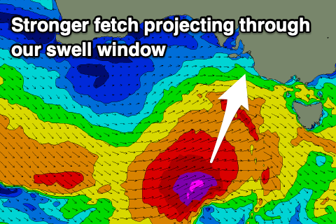
Upgrade in the swell late week
South Australian Forecast by Craig Brokensha (issued Wednesday 26th August)
Best Days: Friday down South, Saturday down South, Sunday morning protected spots down South
Recap
Small, though clean waves across the South Coast the last two days, best on the swell magnets with tiny, clean 1ft sets on the Mid Coast.
This week and weekend (Aug 27 - 30)
Upgrade!
We’ve got an upgrade to Friday’s swell with a strengthening frontal system that’s due to move in from the west now looking quite significant. The models were divergent on the strength of this storm hence I was a little cautious on Monday but looking at the system now, it’s shaping up really nice.
The front is currently south-southwest of WA and will push east fairly rapidly today while deepening. A fetch of severe-gale W/SW winds will be projected through our south-western swell window with core winds possibly reaching storm-force. The speed of the storm isn’t ideal and a bit too quick, but the strength of the fetch should slightly overcome this.
 The front will push through tomorrow evening, with tomorrow seeing a continuation of small 2ft sets across Middleton, tiny on the Mid Coast.
Come Friday, the long-period and moderate to large S/SW groundswell will fill in, peaking through the afternoon with Middleton building from a mid-period 3-4ft in the morning to 4-5ft into the afternoon, The Mid Coast isn’t expected to see much size with tiny 1ft waves for the most part, possibly a touch bigger into the afternoon.
Winds tomorrow will swing from the W/NW to W/SW later afternoon tomorrow with the passing front under us, with great light and local offshore N’ly winds on the South Coast Friday morning, E/NE on the Mid ahead of weak afternoon sea breezes.
Come Saturday the S/SW swell will ease as our new long-range and inconsistent W/SW groundswell fills in. The South Coast should ease back the 4ft range across Middleton, though not drop below 3ft+ with the new swell, while the Mid Coast should offer 1-1.5ft sets.
Winds will freshen out of the N/NE tending N/NW though favouring the South Coast, with stronger NW tending W/NW and then SW winds on Sunday as a strong mid-latitude low moves in from the west.
The models diverge regarding the position and strength of this system but it looks like we’ll see a building mid-period swell for both coasts Sunday, easing Monday with S/SW winds. More on this Friday.


Comments
Nothing like a free upgrade!!!
Thanks for the update swellnet and huey :)