No lack of size, but winds will spoil the party
South Australian Forecast by Craig Brokensha (issued Friday 21st August)
Best Days: Possibly Mid Coast Sunday morning, South Coast Monday morning and Tuesday morning
Recap
A drop in swell with fresh onshore winds across the Mid Coast yesterday and poor 2ft surf, very average down South as well with anywhere showing some sort of wave being blown out.
Today conditions are stormy and to 3ft or so on the Mid Coast with stronger onshore winds, a bit bigger and to 2-3ft down South but with less than perfect conditions.
This weekend and next week (Aug 22 - 28)
The return of stronger westerly winds and rain is linked to a polar front being steered up and into us on the back of a mid-latitude low that pushed through Wednesday.
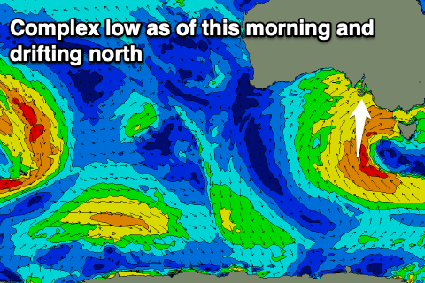
 A low pressure centre formed south-west of Tassie but this is pushing slightly north, pushing the front into us today.
As a result we'll see poor, onshore winds lingering across both coasts now all weekend, strong tomorrow and out of the W/SW tending SW, moderate to fresh SW on Sunday.
A mid-period pulse of S/SW swell due this afternoon from the initial stages of the polar front should reach 4-5ft+ and with the remnants of the front projecting up and into us this evening, 4-6ft surf is due tomorrow morning.
The Mid Coast looks to continue around 2-3ft, easing into the afternoon and then smaller and dropping from 1-2ft on Sunday. There's a chance for lighter S'ly winds early Sunday, but keep an eye on the local weather stations and surfcams for confirmation.
Our reinforcing S/SE swell for Sunday is still on track though the direction looks more S'ly now owing to the fetch on the southern flank of the low sitting a little more west and in our southern swell window.
There'll be plenty of size persisting from this direction Sunday and to 4-5ft down South, easing later and further Monday from 3ft across Middleton.
Our variable breeze for Monday morning is still on track with clean conditions due across the South Coast with a light NW'ly ahead of weak S'ly sea breezes, clean on the Mid though tiny.
Tuesday will see winds shift back to the N/NE but with smaller levels of background swell to 2ft or so off Middleton.
Into Wednesday and Thursday winds will shift more northerly while freshening, but the surf will remain minimal with a weak polar front the best source of small S/SW swell.
Longer term there's some hope for a better swell generating frontal progression moving in from the southern Indian Ocean and under the country through next week, strengthening on approach to us later week.
This looks to bring a moderate sized W/SW groundswell event Friday through next weekend with westerly winds, but more on this Monday. Have a great weekend!

