Onshore, windy swells for the Mid, improving down South from the weekend
South Australian Forecast by Craig Brokensha (issued Monday 17th August)
Best Days: South Coast protected spots Thursday and Friday mornings, Sunday and Monday South Coast
Recap
Generally poor surf over the weekend, tiny on the Mid Coast and small and bumpy down South Saturday, a bit better yesterday with a touch more swell and cleaner conditions around Victor.
Today the surf is clean again down South but small, best suited to the swell magnets.
This week and weekend (Aug 18 - 23)
Well, the outlook for the South Coast this week remains small and slow until Wednesday, while the Mid Coast forecast has become trickier, with the mid-latitude low that's currently moving in from the west now expected to sit higher in the Bight, and just on the edge of the Mid Coast's swell window.
 Currently this low is aiming a fetch of strong W/SW winds through our western swell window and will push east through the Bight, but a secondary intensification on its tail will generate stronger gale-force W/SW winds up towards the Eyre Peninsula.
This isn't ideal for the Mid Coast but it's just within the swell window and we should see the swell from this source filling in Wednesday, mixed in with a local stormy windswell as the low pushes across us.
Looking at tomorrow though and the South Coast is expected to drop in size and become tiny with strong NW winds, building on the Mid Coast to a choppy 2ft with those winds.
Wednesday will then see choppy and semi-stormy conditions with strong onshore W/SW winds on the Mid Coast and 3ft+ waves (likely 3-4ft into the afternoon), while the South Coast will start tiny but increase later to 2ft to possibly 3ft along the Middleton stretch.
The South Coast will see more size Thursday through Sunday from a polar front being projected up on the tail of the low, aiming a fetch of strong to near gale-force S/SW winds up and towards us Wednesday evening and Thursday.
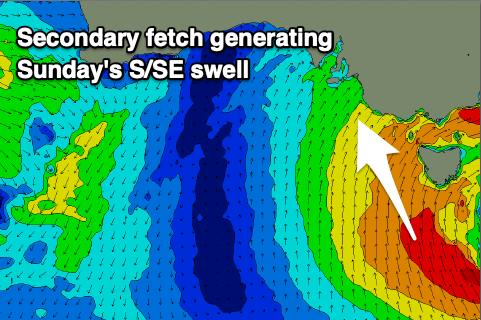
This will then be followed by a fetch of S/SE gales on the south-western flank of a low pressure centre that's forecast to form south-west of Tasmania.
 We should see mid-period SW energy on Thursday to 3ft or so, increasing a little later in the day ahead of a stronger increase in S/SW swell Friday, building to 4-6ft later in the day. A slight drop is then expected Saturday from 4-5ft+, ahead of the S/SE groundswell on Sunday to 4-5ft.
The Mid Coast will see Wednesday's mix of swells easing on Thursday from 2-3ft, though holding Friday around that size with some new weak W/SW windswell. A drop is then due Saturday from 2ft, tiny Sunday.
Winds on Thursday will remain onshore for the Mid Coast and fresh to strong from the W/SW, with W/NW tending W/SW breezes down South, similar through stronger on Friday.
As the frontal system and low push east on the weekend winds will shift SW Saturday (possibly early W'ly around Victor), while Sunday looks much cleaner as winds go variable and locally offshore.
This looks like a great day to surf down South with the moderate sized S/SE groundswell.
Monday should be clean again but easing fairly rapidly in size.
Longer term the outlook is slow for the state again, but we'll have a closer look at this on Wednesday.

