Windy weekend with a new mix of west swells
South Australian Forecast by Craig Brokensha (issued Friday 17th July)
Best Days: South Coast tomorrow and Sunday morning, both coasts Monday (South Coast AM), both coasts Tuesday, Wednesday morning down South
Recap
Clean, small to tiny waves to start off yesterday to 1-1.5ft down South, similar on the Mid Coast, but a new pulse of W/SW groundswell kicked the Mid to 2-3ft through the afternoon as winds tended variable. The South Coast was also fun with the swell kicking in size, though inconsistent.
This morning the size has eased a little back to 1-2ft on the Mid, clean at dawn but now wind affected and a clean 2-3ft down South.
This weekend and next week (Jul 18 - 24)
Yesterday’s inconsistent W/SW groundswell was the first of two, with the second due to build through tomorrow and offer the most size into the afternoon.
This secondary pulse is the better of the two, generated by a stronger polar storm firing up from the west of the Heard Island region, in our far far swell window, but on top the active sea state generated by the storm linked to yesterday afternoon’s swell.
The low broadened while weakening and projecting towards WA, then breaking down in our medium-long range swell window.
It’ll be inconsistent but we should see the Mid Coast kick back to 2-3ft again through the afternoon, with the South Coast slow and to 2ft early off Middleton, building 3-4ft across the stretch to Goolwa into the late afternoon.
 Winds will unfortunately freshen further for the Mid and swing from N/NE to N/NW, favouring the South Coast, while Sunday is best in protected spots with a fresh NW’ly, shifting W/NW and then W/SW mid-afternoon. The swell looks to be a similar if not smaller size, easing through the day.
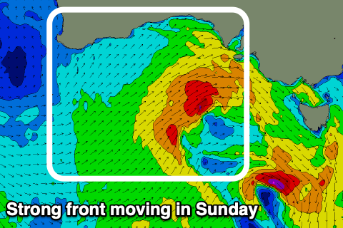
This change in wind will be linked to a vigorous frontal system pushing up and into us, bringing a stormy increase in swell for both regions. The Mid Coast looks to build to 3ft, while the South Coast should kick to 4ft+ by dark.
The origins of this front is a polar storm south-west of WA today. We’re seeing a fetch of gale to severe-gale W/SW winds projected up towards us, but the front will track ahead of the swell and then push through the Bight tomorrow and Sunday.
The groundswell is due Tuesday, but Monday will reveal the short-range swell from the front moving through, persisting around 3ft on the Mid (if not for the odd bigger one) and 4-5ft down South.
Winds should ease fairly rapidly in the wake of Sunday’s change creating workable conditions across both coasts, moderate and W/SW-SW on the Mid, possibly lighter at times and W/NW tending SW down South. Tuesday will become cleaner with variable tending local offshore winds and easing surf from 2ft on the sets across the Mid, 3-4ft down South with some mid-period S/SW energy from the backside of the front pushing up towards Victoria.
Following this the surf will continue to ease into Wednesday with a morning variable breeze, offshore from the N/NW Thursday but small, inconsistent, long-range W/SW groundswells from the Indian Ocean. More on this Monday, have a great weekend!

