Fun for most of the long weekend, new swell mid-late next week

South Australian Surf Forecast by Craig Brokensha (issued Friday 5th June)
Best Days: Saturday morning South Coast, Monday morning South Coast, keen surfers Tuesday morning South Cast, later next week
Recap
Great waves yesterday with a solid and clean S/SW groundswell to 4-5ft on the South Coast, still hanging in at 1-2ft on the Mid Coast which was surprising. This morning the Mid was tiny while the South Coast great again with a drop in size but clean and lined up waves easing from 3ft off Middleton.
This weekend and next week (June 6 – 12)
A new reinforcing S/SW groundswell is due tomorrow morning, ahead of a better pulse into the afternoon, generated the last couple of days. The first swell was generated by pre-frontal fetch of NW tending W/NW winds, with the secondary swell a better polar fetch of gale to severe-gale W/SW winds in our southern swell window.
Middleton should hold 2-3ft tomorrow morning, with the new swell kicking to 3ft+ into the afternoon, then easing from 3ft on Sunday morning. The Mid Coast will remain tiny to flat with the swell being too south to get into the gulf.
Conditions are looking good tomorrow morning with a variable tending locally N’ly breeze, giving into an afternoon S’ly change.
Sunday is now looking dicey with moderate to fresh SE winds due to persist in the wake of Saturday’s change, with better conditions on Monday as winds shift back to the N/NE before afternoon sea breezes kick in.
 The easing trend into Monday will be slowed by a weaker polar front moving in behind the polar low linked to tomorrow afternoon's swell and we should see mid-period S/SW energy to 2-3ft off Middleton, easing into the afternoon and then back to 1-2ft Tuesday. Conditions will be good all day Tuesday as well with a N/NE tending variable breeze.
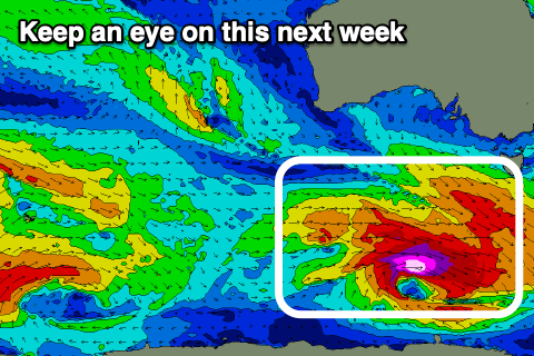
Our next increase in swell is from one of the strengthening polar storms pushing around the southern flank of a broad high moving in from the west next week. We’ll see a good fetch of severe-gale to storm-force W/NW winds generated in our southern swell window, though tracking less than favourably east-southeast.
A moderate sized S/SW groundswell is expected to arrive later Wednesday and peak Thursday with what looks to be favourable wind for the South Coast. More on this Monday, have a great weekend!
Comments
Nice lines across the South Coast this morning.
