Good week of surf down South besides the odd onshore day

South Australian Forecast by Craig Brokensha (issued Monday 1st June)
Best Days: South Coast tomorrow morning, South Coast Thursday and Friday morning, South Coast Sunday morning
Recap
Small to tiny and wind affected waves on the South Coast Saturday, increasing a little through Sunday with favourable conditions through the morning, wind affected again into the mid-late afternoon.
The Mid Coast was a bumpy 1-2ft on Saturday, choppy and to 2ft Sunday morning ahead of a further increase in NW windswell through the afternoon.
Today we've got poor and choppy conditions to 3ft on the Mid Coast with strong SW winds that are now easing. The South Coast is also choppy and to 3-5ft with the slow moving and intense mid-latitude low that moved in yesterday evening now edging east.
This week and weekend (Jun 2 - 7)
As the mid-latitude low linked to the current onshore winds and poor conditions slowly pushes east, we'll see winds shift back to the W/NW tomorrow morning along with a mix of easing SW groundswell and S'ly windswell.
 Size wise the South Coast should ease from 3-4ft off Middleton, 2ft on the Mid Coast and conditions will deteriorate into the afternoon as winds shift W/SW-SW.
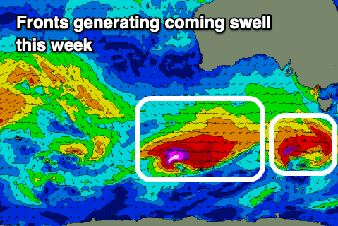
Following the low some good new SW and then S/SW groundswell should be seen into Wednesday and Thursday, produced by the first of two significant frontal systems currently moving through our swell window. This first front is generating a fetch of W/SW gales south-west of Tassie, with the swell due to peak Wednesday morning to 3ft on the sets across Middleton. The Mid Coast looks to drop back to 1ft to possibly 1.5ft on the favourable parts of the tide.
As this swell peaks though, a secondary stronger front that's producing a fetch of severe-gale to storm-force W/SW winds will project up and towards Victoria while weakening Wednesday. This should generate a larger S/SW groundswell for Wednesday afternoon and Thursday morning.
Size wise we should see the South Coast kicking to 4-6ft later Wednesday, easing from a similar size on Thursday, with the Mid Coast persisting around 1ft to possibly 1.5ft on the favourable parts of the tide..
Conditions on Wednesday look poor in the wake of Tuesday's change, followed by a strong high moving in from the west, bringing fresh but easing S'ly tending SE winds.
 Thursday looks great though with offshore N/NE winds and weak sea breezes, great also Friday with N/NW tending SW winds.
Moving into the weekend and a new S/SW groundswell is on the cards for Saturday, generated by a developing polar low in our south swell window late week. An initial pre-frontal fetch of NW winds will be followed by stronger gale to severe-gale W/SW winds south-west of Tassie on the polar shelf.
The S/SW groundswell should build through Saturday and kick to 3ft+ off Middleton though a surface trough moving in from the south-west looks to bring an onshore change around dawn Saturday, hopefully cleaner Sunday as winds tend back E/NE-NE and the swell eases. We'll have a closer look at this Wednesday though.