Our run of clean conditions comes to an end
South Australian Forecast by Craig Brokensha (issued Wednesday 20th May)
Best Days: South Coast Friday, South Coast Monday
Recap
Not the cleanest conditions on the Mid Coast yesterday but there were workable windows at dawn and into the afternoon ahead of a strong onshore change with 2ft or so of swell. The South Coast was great most of the day ahead of the late kick in winds from the W/NW.
Today conditions are still fun down South with a moderate W/NW breeze and 2-3ft of swell across Middleton, choppy and poor to 2ft on the Mid Coast.
This week and next (May 21 - 29)
A strong SW change due this evening will be linked to a strong cold front clipping the state. A good new S/SW groundswell will build into tomorrow afternoon in the wake of this front, generated by a good fetch of S/SW gales at its base that have been projected towards us.
An initial increase in S/SW windswell will be seen tomorrow morning to a junky 3ft+ or so across Middleton, with the groundswell due to kick to a stronger 4ft+ into the late afternoon. Strong S/SW winds will create poor conditions, while the Mid Coast looks to offer 2ft sets, but choppy conditions.
Friday morning looks to still offer cleaner conditions in protected spots down South as winds shift back to the W/NW along with a new, large building S/SW groundswell.
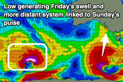
 The groundswell will be produced by a polar low today and early tomorrow (at the base of this evening's front), with a great fetch of severe-gale SW winds being projected up towards Tasmania, through our southern swell window.
The groundswell is due to build Friday and peak into the afternoon with most locations due to kick to 6ft or so, larger on the deep water reefs and exposed beaches. With this though winds will shift back to the SW-S/SW through the afternoon creating bumpy conditions. The Mid Coast may see an early variable breeze but likely be a bumpy and lumpy 1.5ft or so.
Unfortunately winds are still set to be onshore into the weekend down South with moderate to fresh S'ly winds Saturday as the S/SW groundswell eases back from 4-6ft, S/SE Sunday as a new SW groundswell fills in.
This groundswell will be generated by a strong polar low forming south-west of WA and tracking unfavourably to the south-east but while generating a significant fetch of severe-gale to storm-force W/NW winds.
Middleton should hold around 3ft+ through Sunday, though tiny on the Mid Coast, easing Monday as winds swing back to the E/NE-NE through the morning.
Now moving into Tuesday and beyond, we'll see the start of a significant Southern Ocean frontal progression in the form of an initial mid-latitude low and stronger follow up systems, under the influence of a strong node of the Long Wave Trough, but more on this Friday.

