Great run for the South Coast
South Australian Forecast by Craig Brokensha (issued Wednesday 13th May)
Best Days: Every day down South, Mid Coast tomorrow and Monday
Recap
Tiny and choppy waves on the Mid Coast yesterday, though building into the late afternoon with the arrival of a new swell. The South Coast was clean and great through the morning, with options reducing into the afternoon as winds shifted fresher NW.
Today our new W/SW groundswell is peaking across both coasts though a trough has brought a S/SE change, creating poor conditions down South and clean waves on the Mid with 2ft sets on the magnets. The outgoing tide is taking away the size and consistency but the incoming pulse should provide 3ft sets before it gets too full.

This week and weekend (May 14 - 17)
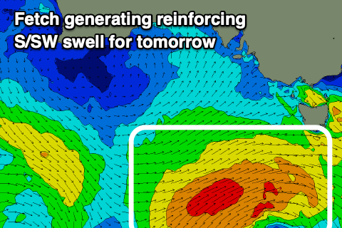
Today's W/SW groundswell will peak through the day, easing through tomorrow as winds swing back offshore across the South Coast and remain favourable for the Mid Coast. A reinforcing S/SW swell will be seen down South though, generated by the remnants of the progression linked to today's swell.
 A fetch of strong to gale-force SW winds were generated in our southern swell window and we can expect this to keep 3ft to occasionally 4ft sets hitting Middleton tomorrow morning, easing through the day and then back to 2ft Friday. The Mid Coast should ease back from 2ft on the sets tomorrow, tiny Friday.
A light E/NE breeze is expected on the Mid tomorrow morning, giving into weak sea breezes, with N/NE tending E'ly winds down South.
Friday looks to play out similar, best down South.
Moving into Saturday, a new background SW swell should stop the easing trend down South with small sets to an inconsistent 2ft persisting along the Middleton stretch, tiny on the Mid Coast with fresher N tending N/NW winds.
From Sunday through Wednesday though we'll see good pulses of W/SW groundswell along with favourable winds as a conveyer belt of storms moves through our medium-range swell window.
The models have aligned with EC resulting in no major spike in size through this period but moderate sized swells.
Multiple mixed fetches of gale-force W/NW winds will move through our swell window, west-south-west of WA, with embedded lows generating bursts of stronger severe-gale winds.
The progression will weaken when moving under the country Friday, with some new inconsistent W/SW groundswell due from this flurry Sunday, building through the day. Building sets to an inconsistent 3ft are due off Middleton, 1-2ft later on the Mid Coast, though peaking Monday to 3ft+ and 2ft respectively.
 A stronger and more consolidated front projecting gale to severe-gale W/SW winds on the back of this progression through our western swell window, south-west of WA should generate a better W/SW groundswell for Monday afternoon and Tuesday morning. Sets to 4ft are due off Middleton, with the Mid Coast likely to see 2-3ft sets.
Local conditions look favourable with Sunday seeing N/NE tending E'ly winds on the South Coast, E/NE-NE tending variable on the Mid with Monday seeing fresher N/NE tending variable breezes, stronger from the N/NE on Tuesday with an approaching mid-latitude low.
Yet another pulse of good W/SW groundswell is due Tuesday afternoon and Wednesday but with a W'ly change. More on this and the specifics of the coming swells Friday though.

