Easing surf with winds out of the north-eastern quadrant
South Australian Forecast by Craig Brokensha (issued Wednesday 3rd July)
Best Days: Today, Mid Coast keen surfers tomorrow, same with down South, South Coast Friday, later Saturday, Sunday and Monday morning
Recap
Yesterday's new W/SW groundswell came in a touch under expectations across both coasts, with the Mid a lumpy and bumpy 2-3ft, while the South Coast built to the 4-5ft range off Middleton through the day.
This morning the surf was a similar size across both coasts and more in line with forecast but much cleaner on the Mid with great 2-3ft sets on the magnets as shown below, and clean/lumpy 4-5ft surf off Middleton and fun options around Chiton.


Today’s Forecaster Notes are brought to you by Rip Curl
This week and weekend (Jul 4– 7)
Over the coming days we'll see the swell continuing to ease, not the cleanest down South tomorrow and much better Friday.
Size wise, Middleton should still see 3-4ft sets along the Surfers stretch with easing 2ft sets on the Mid Coast on the favourable parts of the time (mostly 1-2ft). Conditions will be best on the Mid Coast tomorrow with an E/SE tending variable breeze and peaky/bumpy down South with a moderate E/NE morning wind, onshore through the afternoon.
The Mid will become tiny into Friday but the South Coast should still see 2ft+ sets off Middleton, holding most of the day with an inconsistent background SW groundswell. A fresher NE tending N/NE breeze will favour Goolwa and more exposed breaks all day.
 Saturday looks great again with a fresh and gusty N/NE offshore but leftover and easing 1ft to maybe 2ft wave off Middleton, 2ft+ at Waits and Parsons.
Our mix of new inconsistent W/SW groundswell for Sunday and closer-range W/SW for later and Monday morning are still on track.
The initial swell was generated around Heard Island the last couple of days by a great but distant fetch of SW gales were projected towards Indonesia, with the storm currently weakening west-southwest of WA.
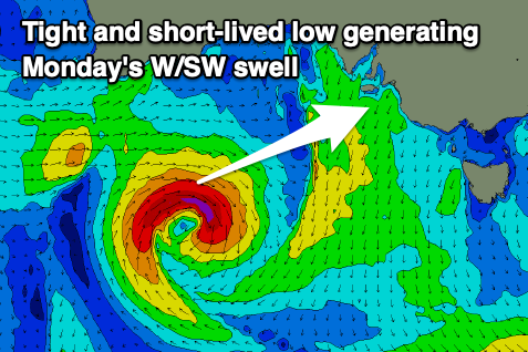
This swell will be very inconsistent, arriving later Saturday but peaking Sunday morning to an inconsistent 2ft+ on the sets across Middleton and 1-1.5ft on the favourable parts of the tide on the Mid. The remnants of the storm will form into a tight mid-latitude low under WA tomorrow evening, producing a very small fetch of W/SW gales in our western swell window.
A small W/SW swell is due off this low, coming in at a similar size to the long-range swell, arriving late Sunday and easing Monday.
Winds on Sunday will shift from NW to SW as a weak front moves through, better Monday morning as winds swing back to the N/NW. Longer term there's nothing too significant on the cards until late next week so make the most of the current swell and coming days.

