Tons of swell to come, largest and cleanest next week
South Australian Forecast by Craig Brokensha (issued Friday 28th June)
Best Days: South Coast tomorrow, Sunday and Monday, Mid Coast Tuesday and Wednesday and Thursday, South Coast Tuesday morning, Wednesday, Thursday, Friday
Recap
Another fun day on the swell magnets across the Surf Coast yesterday with tiny waves off Middleton, building into the late afternoon a touch. The Mid Coast was tiny and bumpy.
Today our first inconsistent long-period W/SW groundswell has filled in offering 2ft sets on the Mid Coast though with bumpy and choppy conditions, cleaner down South and with a little bump in size. We may see a further bump in size later today as the larger and stronger secondary pulse of W/SW groundswell starts to fill in as winds remain fresh from the N-N/NE.
Today’s Forecaster Notes are brought to you by Rip Curl
This weekend and next week (Jun 29 – Jul 5)
Later today's secondary and larger pulse of W/SW groundswell is expected to peak tomorrow morning to an inconsistent 3ft on the sets across the Mid Coast working the favourable parts of the tide, with 3ft+ waves off Middleton, more to 4ft towards Goolwa.
The swell is likely ease into the afternoon, and a strong low forming directly under us tomorrow will fail to generate any real additional size.
Winds will be poor for the Mid Coast and fresh from the N/NW, shifting W'ly through the day, while the South Coast will be best early with the N/NW offshore, shifting W/NW and then W/SW late.
Sunday is expected to drop back to 2ft on the Mid Coast with a reinforcing mid-period W/SW swell maintaining size, while Middleton looks to ease back from 3ft, though inconsistent.
 Winds will improve through Sunday and swing from the W/NW in the morning to the NW through the afternoon down South, opening up more options for the late session.
Monday will be clean again but the swell small and to 2ft off Middleton with a moderate to fresh N/NW-NW offshore.
Later in the day we'll likely see some new W/SW swell showing on the Mid Coast, the precursor to a much larger W/SW groundswell on Tuesday.
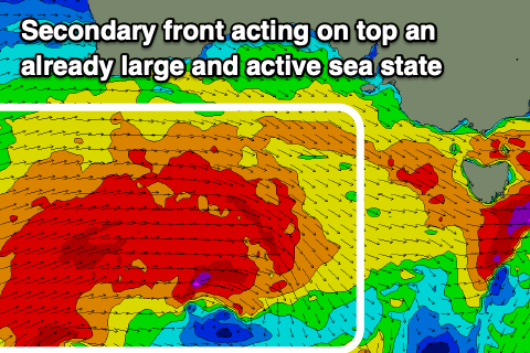
The frontal progression linked to this swell has already started to develop in the Heard Island region. We're seeing a fetch of gale to severe-gale W/SW winds projected up towards Western Australia today, further towards the Bight over the weekend. This first front will be followed by a secondary system developing right on its tail, projecting similar strength winds under WA's south coast Sunday on top an active sea state. The progression will continue slowly east without losing much steam on Monday before pushing under us into the evening.
A large, long-period W/SW groundswell will be generated, building late Monday likely to 2ft on the Mid Coast, while Tuesday will see solid 3-4ft sets at magnets on the Mid Coast, with Middleton building to an easy 6ft through the day.
Winds still look onshore but workable, with an early window of W/NW winds down South, shifting SW around midday or so, while the Mid Coast may see a dawn N/NE breeze, shifting NW and then SW but without too much strength. This should create decent waves most of the day.
Wednesday will see variable tending locally offshore winds as the large W/SW groundswell eases from a solid 3ft on the Mid Coast and 5-6ft off Middleton.
Into the end of the week the swell will continue to ease with favourable winds for both coasts, NE-N/NE Thursday morning and fresher N/NE on Friday. We'll have one more look at the local winds for Tuesday/Wednesday's swell on Monday so check back then. Have a great weekend!

