Fun surf days to come, large out of the W/SW next week
South Australian Forecast by Craig Brokensha (issued Wednesday 26th June)
Best Days: South Coast later tomorrow, Friday, keen surfers late Friday Mid Coast, protected spots down South all weekend, Monday morning down South, Mid Coast Wednesday
Recap
Tiny offerings on the Mid Coast while the South Coast has been perfect condition wise, but on the tiny side as well along the Middleton stretch. Waits and Parsons have been the pick for small fun offerings.
Today’s Forecaster Notes are brought to you by Rip Curl
This week and next (Jun 27 – Jul 5)
Tomorrow morning will start on the tiny side across all coasts again, best at Waits and Parsons with small sets around 2ft+ under a moderate to fresh N/NE offshore.
Into the afternoon the first pulse of inconsistent and long-range W/SW groundswell should start to show, ahead of a peak Friday morning. Size wise Middleton may see sets pushing to 2ft later in the day, a bit bigger towards Goolwa, with Waits and Parson to 3-4ft under that persistent N/NE offshore.
The Mid Coast will likely kick to 1-1.5fft, while Friday will reveal the most size with 2-3ft sets along the Middleton stretch and sets to 2ft on the Mid Coast working the favourable parts of the tide.
Winds will become an issue for the Mid Coast and be bumpy cross-shore out of the N/NE, tending N/NW for a period into the afternoon. This South Coast will be the pick and offshore all day.
Now, later in the day the better and larger pulse of W/SW groundswell will likely be seen ahead of a peak Saturday morning.
This swell will have more west in it and offer the most size with the Mid Coast expected to see strong 3ft sets, possibly on dark Friday but more so Saturday working the favourable parts of the tide. Middleton should come in around 3ft+ with 4ft sets down towards Goolwa and more size again at Waits and Parsons, but expect long waits for the bigger ones.
Winds will shift NW Saturday morning creating bumpy conditions on the Mid Coast, shifting more W/NW down South and favouring protected spots, which will be smallest.
A late drop in size is due across both coasts Saturday with a further easing in size Sunday back to 2ft on the Mid Coast (holding all day though with a reinforcing mid-period W/SW swell) and easing 3ft sets off Middleton.
Winds will remain onshore for the Mid but improve through the day down South with a W/NW tending NW offshore with an approaching front.
No additional swell is expected off this front, with easing 1-2ft Mid Coast waves Monday and smaller 2ft surf off Middleton with a N/NW offshore.
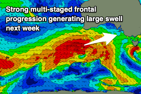
 Moving into the middle of the week and as touched on last update, a node of the Long Wave Trough will move in from the west, bringing with it a flurry of strong frontal activity closer to us and under the country.
An initial polar front developing just east of Heard Island will project a fetch of severe-gale W/SW winds up towards Western Australia, through our western swell window, continuing slowly east with multiple intensifications over the weekend. The progression will broaden and break up a little under the country on Monday, but still maintain a patchy fetch of W/SW gales through the Bight, clipping the state on early Tuesday morning.
A large long-period W/SW groundswell will be generated, building Tuesday and peaking into the afternoon to an easy 6ft off Middleton and kicking to 3-4ft on the Mid Coast. Winds will unfortunately be onshore out of the SW in the wake of the change early Tuesday morning. We'll likely see a morning S/SE breeze on Wednesday as the swell remains large but eases, from 3ft+ on the Mid Coast and 5-6ft down South.
Check back Friday for any adjustments to the swell size and local winds.

