Small to end the week with lots of swell from the weekend
South Australian Forecast by Craig Brokensha (issued Wednesday 3rd April)
Best Days: Selected breaks Thursday, magnets early Friday, Mid Coast Saturday afternoon, South Coast Sunday morning and Monday, both coasts experienced surfers Tuesday
Recap
Pumping waves all day yesterday across the South Coast with an offshore breeze and easing swell from a good 3ft off Middleton. Today the surf was back to a small 1-2ft, best at Waits and Parsons with perfectly clean conditions. How good is this time of year!
The Mid Coast was a tiny 1ft yesterday, near flat today.
Today’s Forecaster Notes are brought to you by Rip Curl
This week and next week (Apr 4 - 12)
The end of the week is looking small though fun on the South Coast magnets. A slight lift in new SW tending S/SW swell is due tomorrow generated by a weak but strengthening front that passed under us last night.
The strength of this system late in our swell window was impressive, but size wise we're not expected to see much over 2ft+ across Middleton, better at Waits and Parsons and to 3ft+ or so. The Mid Coast is only due to be tiny with 1ft sets. Winds will be more from the E/NE-NE tomorrow morning, so spots like Goolwa and protected points will be cleanest.
The swell will fade through Friday from a small 1-2ft off Middleton with better N/NE offshores, strengthening and tending N/NW, flattening the surf into the afternoon while kicking up a poor N/NW windswell on the Mid Coast.
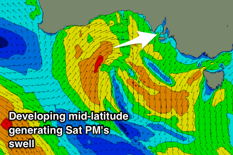
Saturday will start tiny, but a good new W/SW tending SW swell will build into the afternoon, generated by a deepening trough come mid-latitude low moving in through the Bight and drifting east-southeast through our swell window.
 The low will take a little longer to form and now winds look strongest when it's in our south-western swell window, resulting in a slight drop in the size expected on the Mid Coast.
Still we should see an afternoon kick in sized to 2ft to occasionally 3ft on the Mid Coast Saturday, with moderate but easing SW winds, variable later in the day.
The South Coast will build later to 3ft+ though will be average with those onshore winds.
Sunday is the pick down South with a shift in winds to the W/NW through the morning along with easing 3ft sets off Middleton, bumpy and to 2ft+ or so on the Mid Coast.
We then look to the large and powerful groundswell event due into early next week.
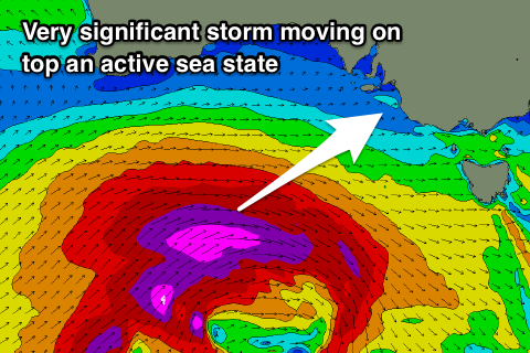
 Around the Heard Island region today an intense polar low will form, projecting slowly east while generating gale to severe-gale W/SW winds before weakening while being steered up and under the country through the weekend.
Besides generating a building and strengthening SW groundswell for Monday it will also set up an active sea state for a much more significant polar storm to move over, with this front projecting a fetch of severe-gale to storm-force W/SW winds up through our swell windows on the weekend before moving across us Monday.
An oversized long-period SW groundswell is expected to arrive very late Monday but peak Tuesday morning to the 8ft range off Middleton and deep water reefs, if not for the bigger cleanup set and 3ft+ on the Mid Coast.
Winds will shift from a strengthening W/NW breeze Monday to the S/SW in the wake of the front on Tuesday which will favour the Mid Coast rather than the South Coast. In saying this the strength of the swell and lack of strength in the wind should still open up options down South.
Winds look to swing more E/NE Wednesday morning as the large swell slowly eases, though it'll be far from perfect. More on this Friday though.

