Great weekend down South, larger surf next week

South Australian Forecast by Craig Brokensha (issued Wednesday 6th March)
Best Days: South Coast Saturday and Sunday mornings, both coasts Wednesday morning, South Coast Thursday morning
Recap
Pumping waves both yesterday and this morning across the South Coast with plenty of size and power on the former. The Mid Coast offered fun though inconsistent 1-2ft sets yesterday morning, tiny into today.
Today’s Forecaster Notes are brought to you by Rip Curl
This weekend and next week (Mar 9 - 14)
The weekend will be nice and clean across the South Coast with a fun new long-period S/SW groundswell for tomorrow, easing through the afternoon and small Sunday.
The groundswell was generated by a very intense but late forming low in our swell window, south of us yesterday.
Size wise we should see strong 3-4ft sets out of the S/SW across Middleton, with the chance of the rare bigger one, while the Mid Coast will remain tiny.
A morning variable breeze should great good clean conditions ahead of afternoon sea breezes, while Sunday will be fun with a light morning W/NW breeze ahead of a shallow SW change later morning. The swell will be smaller though and easing from 2ft+ off Middleton, better at swell magnets.
A low point in swell is likely Monday morning with an early W/NW breeze possible around Victor, but with no considerable size. Winds are likely to be SW and a fun new mid-period W/SW swell should build into the afternoon ahead of a stronger, larger but less consistent long-period SW groundswell Tuesday morning.
A strong polar front that's currently in the Heard Island region will produce the long-period energy, with it projecting east-northeast towards WA while weakening today and tomorrow. A weaker pre-frontal W/NW fetch will generate the mid-period and more westerly swell, arriving Monday afternoon and building to 1ft+ later, with a peak Tuesday to 1ft to possibly 2ft on the favourable parts of the tide.
 Middleton should build to 2-3ft later in the day Monday and peak Tuesday morning to 3ft+ though conditions across both coasts will be less than ideal with a fresh W/SW tending SW breeze. There's a chance of an early W'ly around Victor but we'll review this Monday.
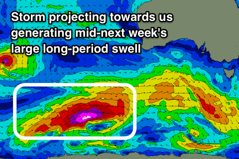
Tuesday's stronger onshore winds will be related to a vigorous cold front pushing up and into us, bringing a large long-period SW groundswell Wednesday.
The swell will be generated by a vigorous polar storm developing tomorrow morning just east of Heard Island, with a fetch of storm-force W/SW winds forecast to be projected through our south-western swell window, weakening as the storm broadens south of WA Sunday evening before pushing up and into us Tuesday.
The movement of this storm on top an active sea state and at a speed similar to the swell its producing should result in a significant long-period SW groundswell, arriving overnight Tuesday and peaking Wednesday to 6-8ft off Middleton 2ft to occasionally 3ft on the Mid Coast.
Winds look best for the Mid Coast and offshore out of the E/SE, with the South Coast lumpy and wobbly as winds possibly go light and variable E.
Thursday will be similar with variable winds out of the E as the groundswell eases. Later in the week a small low may generate a reinforcing SW groundswell for Friday but with average SE winds. More on this Monday though. Have a great weekend!
Comments
Nice long lefts rolling through at Day Street.

No shortage of size at Middleton either!

Being out due to injury was fine while the typical summer patterns persisted, but now Autumn is making its influence felt the withdrawal symptoms are starting to kick in big time. Ben, Craig - can you please just keep the summer doldrums going for a couple more weeks?