Good long-period swells with favourable winds
South Australian Forecast by Craig Brokensha (issued Monday 4th March)
Best Days: Later Wednesday Mid Coast, Thursday both coasts, Friday morning South Coast, both coasts Saturday morning, South Coast Sunday morning
Recap
Tiny to flat surf to start off Saturday, getting better through the day down South with a small kick in swell, while a new W/SW swell started to show on the Mid Coast Sunday morning with clean peaky 0.5-1ft sets, pulsing further into the afternoon. The South Coast was average and bumpy.
Today the W/SW swell is peaking with good clean 2ft waves on the Mid Coast, onshore and average down South.

Today’s Forecaster Notes are brought to you by Rip Curl
This week and weekend (Mar 5 - 10)
 Today's pulse of swell will ease back through tomorrow and winds look funky across the South Coast. We may see a dawn SW'ly tend W/NW for a short period through the morning around Victor but with small easing 2ft sets. The Mid Coast should be clean with a S/SE breeze though fading 1-1.5ft sets max.
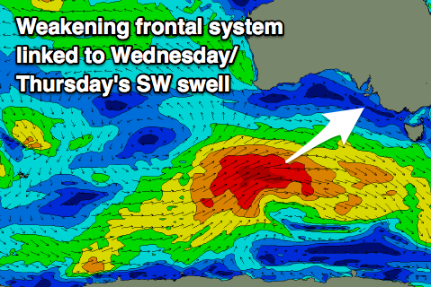
More exciting is the moderate to large long-period SW groundswell due Wednesday and Thursday across the state.
A strong low developed Friday evening in our far swell window and has since generated a fetch of severe-gale to storm-force W'ly winds south-west of WA.
The storm has weakened a touch but is still generating an expansive fetch of gale to severe-gale W/SW winds south of WA this morning. The storm will continue east while slowly easing today, with the front pushing up and into us Tuesday evening.
We should see the swell filling in steadily on Wednesday and building from 3-4ft to 4-5ft+ by mid-late afternoon, with the Mid Coast building to a good 2ft, mixed in with some weak local windswell.
Winds will be average with a fresh and gusty SW wind across the South Coast Wednesday, S/SW on the Mid Coast though tending S/SE later in the day, creating improving conditions.
Thursday is still the day to surf as winds swing offshore across all locations along with easing 2ft sets on the Mid Coast, 4-5ft off Middleton. The Mid Coast should see NE tending lighter NW winds, N/NE tending NW on the South Coast creating an excellent day of surfing.
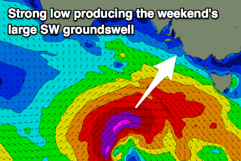
 The surf should continue to ease Friday morning, but later in the day a new long-period SW groundswell is due to build across the state, peaking Saturday morning.
The models were undecided on the development of the low linked to this swell, but are now in alignment and we should see this low develop south of WA Wednesday night, with a great fetch of severe-gale to storm-force W/SW winds projected east towards Tassie.
Winds Friday morning should be offshore and the surf clean again across both coasts, with sea breezes into the afternoon, variable Saturday morning with strong 4-5ft sets off Middleton, 1-1.5ft on the Mid Coast.
A further drop in size is due Sunday as winds swing to the west, but longer term the outlook remains more than active with a strong node of the Long Wave Trough developing across the south-east of the country due to bring large surf next week. More on this Wednesday.


Comments
Thursday it is then, finally some size and clean conditions, hope the seaweed is washed away in the bay by then lol :-)
Any suggestions on where to surf the south coast for a low intermediate on Thursday morning?
First Carpark at daystreet or maybe dump.
Thanks
I wouldn't say The Dump as it's more for experienced riders with rocks on the inside.
Try Day St or the Surfers stretch but don't expect to get out the back. It will be breaking way out, but inside there should be some fun whire-wash reforms.
Thanks Craig