Plenty of swell and wind from tomorrow
South Australian Forecast by Craig Brokensha (issued Friday 8th February)
Best Days: Protected spots Sunday morning South Coast, Monday South Coast, possibly Wednesday morning South Coast, Thursday morning South Coast
Recap
A weaker onshore breeze yesterday morning and OK waves for desperate surfers on the South Coast, tiny on the Mid. Today the surf is a mess down South and tiny and bumpy on the Mid.
Today’s Forecaster Notes are brought to you by Rip Curl
This week and weekend (Feb 9 - 15)
From tomorrow were set to see a flurry of different swells of different strengths and directions owing to a strong node of the Long Wave Trough stalling across the south-east of the country.
The first frontal system falling under it's spell is currently south of the Bight and it's been upgraded in strength a little.
A good fetch of strong W/SW tending SW winds are being projected towards us through our south-western swell window, with this system due to push into the south-east of the state early tomorrow.
This will bring a mix of building windswell and mid-period SW swell tomorrow, reaching an easy 4ft across Middleton into the afternoon and 1-2ft on the Mid Coast but with deteriorating W/NW tending SW winds. The morning will be clean in protected spots down South but minimal in size.
 We'll see the mid-period energy peak Sunday and this should keep Middleton around 4ft in the morning, easing off slightly into the afternoon and back more so to 2-3ft on Monday morning as we fall between swells. The Mid looks to ease back from 1-2ft and be more so around 1-1.5ft.
Winds should tend back to the W/NW across the South Coast Sunday morning, W/SW on the Mid Coast, with the afternoon being bumpy as winds swing more SW.
Monday will see slightly cleaner conditions across more exposed breaks on the South Coast as an approaching front tips winds more W/NW-NW, holding most of the day before tending back W/NW through the afternoon.
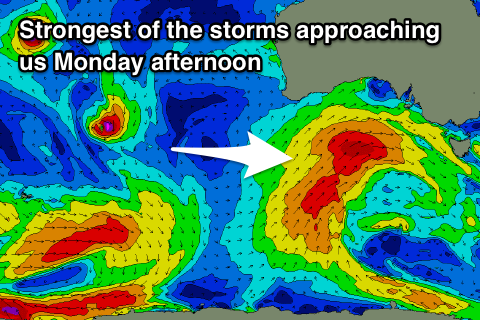
This approaching front will be the strongest of them all, forming on the polar shelf south-southwest of WA and projecting a good fetch of SW gales up and into us, passing under the South Coast Tuesday morning, followed by a slightly weaker secondary SW fetch.
We'll see building levels of SW swell through Tuesday, reaching 4-5ft+ at least through the afternoon ahead of a peak Wednesday morning to 4-6ft. The Mid Coast will see a mix of windswell and groundswell building Tuesday to an easy 3ft, dropping back to 2-3ft Wednesday.
Winds on Tuesday will be accordingly average and strong from the W/SW, tending SW and easing through the day. Wednesday looks to see lingering moderate to fresh SW breezes, but hopefully we'll see an early W'ly on the South Coast. Thursday looks a better chance of this and there'll still be plenty of swell as the easing trend is slowed by back up frontal activity in the wake of the strongest storm. More on this Monday though. Have a great weekend!


Comments
Hi Craig
I was just wondering when the Christies Beach cam will be back in action. It's been down for months. Very handy for a pre stormy sesh.
Cheers!