Plenty of good surf days to choose from this week
South Australian Forecast by Craig Brokensha (issued Monday 28th January)
Best Days: Both coasts tomorrow and Wednesday morning, Mid Coast Thursday and Friday morning, South Coast Saturday morning
Recap
A new building swell on the Mid Coast Saturday which reached 1-2ft into the afternoon with light variable winds, back to 1-1.5ft on Sunday. The South Coast saw light winds and clean conditions Saturday morning with the building swell, holding Sunday morning with workable light onshore winds.
Today the our new pulses of W/SW and SW groundswell are on the build with good clean 1-2ft waves on the Mid this morning with 3-4ft sets on the South Coast.
We should see the SW groundswell peaking this afternoon to a consistent 4ft off Middleton and 2ft on the Mid Coast, if not for the odd sneaky bigger one.
Today’s Forecaster Notes are brought to you by Rip Curl
This week and weekend (Jan 29 – Feb 3)
This afternoon's increase in SW groundswell is the first of two due this week, with the second expected into later tomorrow afternoon/evening and Wednesday morning.
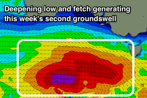
 This secondary pulse is being generated by the strongest of the fronts that have moved through our swell window the last couple of days. It's currently south of the Bight with a great fetch of severe-gale W/NW winds and tight storm-force fetch at its tail.
The storm is further south and forming later in our swell window and this will put a cap on the expected size due later tomorrow.
In the morning Middleton should be around 3-4ft, with 1-2ft sets on the Mid Coast, not increasing until the afternoon with a late kick to 4ft to possibly 5ft on the sets at Middleton as the Mid Coast maintains its size.
The swell should then ease back through Wednesday from the 4ft range and 1-2ft respectively. Winds locally tomorrow should be good and variable, tending offshore before afternoon sea breezes kick in, while Wednesday looks similar with a N/NE tendency shifting W/SW into the afternoon ahead of a gustier S/SW change later as a front moves in from the west.
This front will bring with it some fun reinforcing mid-period W/SW swell for the Mid Coast, with it forming on the backside of the strong storm currently south of us. A broad and elongated fetch of strong W/SW winds will project up towards WA, with a couple of stages to the progression, producing a fun W/SW swell to 1-2ft on the Mid Coast Thursday and Friday morning.
Middleton will be a touch smaller and hover around 3ft+ Thursday, easing from 3ft Friday morning but with S'ly winds Thursday and E/SE winds Friday morning, the Mid will be the pick.
Saturday will become clean down South with an E/NE tending NE offshore but with small easing 2ft waves off Middleton, tiny on the Mid Coast.
Longer term isn't too flash with back to back high pressure systems forecast to move in through the Bight, directing constant S/SE winds across the state while deflecting any major storms away from us. More on this Wednesday.


Comments
Swell is kicking in lovely..