Good run of waves from Sunday
South Australian Forecast by Craig Brokensha (issued Friday 25th January)
Best Days: South Coast early Sunday in protected spots, Monday both coasts, Tuesday morning both coasts, Wednesday morning both coasts
Recap
Well what a day! The hottest for a lot of locations yesterday, with the heat extending to nearly all regions of the state. Surf wise we saw a fun peaky mix of swells easing from the 2ft range off Middleton yesterday, cleaning up as the day progressed, with tiny to flat conditions on the Mid.
Today we’ve got much cooler conditions and tiny amounts of swell on both coasts.
Today’s Forecaster Notes are brought to you by Rip Curl
This weekend and next week (Jan 26 – Feb 1)
The weekend will start poor but improve from there.
Firstly the swell from a weakening mid-latitude low moving in from the west has been upgraded with a better than forecast fetch of strong W/SW winds generated in the Mid’s western swell window, under WA yesterday.
We’re now expected to see the Mid Coast build to 1-2ft through the afternoon, though conditions will be deteriorating with an early S/SE breeze due to tend SW and freshen from the W/SW later.
The South Coast will be average with weak onshore winds and small surf in the morning, ahead of a new long-period SW groundswell into the afternoon. There’s been no change to the expected size off this swell with Middleton due to reach 3ft, if not for the odd sneaky bigger one but with those fresher onshore winds.
The swell will ease into Sunday from a similar size and we’ll likely see a morning W/NW breeze around Victor before tending SW mid-late morning.
Of greater importance are the swells due into next week.
As touched on last update we’ve got a great run of W/SW and SW swell due from Monday.
The catalyst for this swell event will be a strong node of the Long Wave Trough moving in very slowly from the west from this evening.
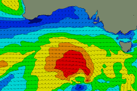
With this we’ll see an initial relatively weak polar front project up towards WA and the under the Bight, generating strong W/SW winds. A fun mid-period W/SW swell will be generated by this front alone, but a stronger mid-latitude front will race in on top of the active sea state and generate an additional fetch of W/SW gales Saturday afternoon through Sunday (pictured below right).
 This will boost the size and strength of the swell due on Monday from a more SW direction, with the mid-period energy arriving just ahead of the groundswell into the afternoon.
We should see Middleton building from an easy 3ft+ to a strong 4ft into the afternoon with the Mid Coast building to a good 2ft, if not for the odd sneaky bigger one.
Winds look good for both coasts on Monday morning with a variable breeze, ahead of relatively weak sea breezes and then variable E/NE breezes Tuesday morning as the swell eases just a touch.
On the backside of these initial fronts a much stronger mid-latitude storm will develop, forming into a deep low resulting in a fetch of severe-gale W/NW winds developing late in our swell window.
This should produce a new long-period SW groundswell for Tuesday afternoon, with Middleton kicking back to 4ft on the sets, with 1-2ft waves persisting on the Mid Coast.
Sea breezes look fresher Tuesday afternoon, while Wednesday morning looks great as the swell eases under a N/NE offshores.
Longer term a deepening mid-latitude low will bring an onshore increase in windswell to both coasts late week, but more on this Monday. Have a great weekend!

