Poor weekend, upgrade in swell early next week
South Australian Forecast by Craig Brokensha (issued Friday 18th January)
Best Days: Mid Coast Monday afternoon and Tuesday morning, keen surfers South Coast Monday afternoon and Tuesday morning
Recap
Yesterday's reinforcing pulse of W/SW swell kept good 1-2ft sets hitting the Mid Coast (above expectations) with small fun waves off Middleton, better out at Waits and Parsons until a change moved through.
This morning the size has eased off across both coasts with early variable winds which are now giving into a slightly stronger onshore change.
Today’s Forecaster Notes are brought to you by Rip Curl
This weekend and next week (Jan 19 - 25)
There's been no change to the weekend outlook with stronger S'ly winds due to kick in overnight tonight, remaining fresh tomorrow out of the S/SE kicking up a poor increase in windswell.
Slightly better SE breezes are due Sunday morning, possibly even tending E/SE but there'll be no groundswell or waves of quality.
The Mid Coast is expected to hover around 0.5-1ft tomorrow before bottoming out Sunday.
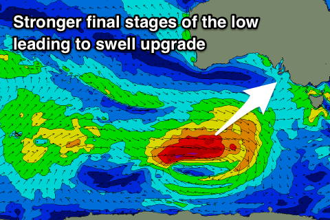
Of greater importance is the long-period W/SW-SW groundswell due Monday, with an upgrade in the strength of the storm generating the swell, resulting in more size for our state.
A strong and tight low formed north of Heard Island during the middle of this week, generating a tight fetch of severe-gale to storm-force W'ly winds in our far western swell window.
 The low was expected to weaken while tracking east-southeast through our south-western swell window, but instead we're now due to see the low generating a persistent fetch of severe-gale W'ly winds.
This will produce a more consistent long-period SW groundswell that will come in larger than the W/SW component.
We should see both swells arriving Monday morning, with a strong increase to 4-5ft due across the Middleton stretch, while the Mid Coast is still due to reach an inconsistent 2ft on the sets.
Winds will remain average for the South Coast and out of the SE-E/SE through the morning, great for the Mid ahead of SW sea breezes with a return to S/SE winds late.
Unfortunately as the swell eases Tuesday it looks like conditions will continue to remain average down South with an E/SE breeze, though there's an outside change for light morning E'ly breezes. We'll review this Monday though and in any case with the strength of the swell there should be some fun options.
Into the end of the week there's nothing of significance due as a deepening mid-latitude low south of WA puts a block on our swell windows and directs winds from the eastern quadrant across us. Have a great weekend!

