New swell on the build, fun tomorrow
South Australian Forecast by Craig Brokensha (issued Monday 14th January)
Best Days: Both coasts tomorrow morning, keen surfers South Coast magnets Wednesday and more so early Thursday morning
Recap
Poor waves all weekend on the South Coast with moderate to fresh SE-S/SE breezes, while a tiny swell due for the Mid Coast Sunday wasn't present during the morning, with a tiny 1ft wave seen into the afternoon.
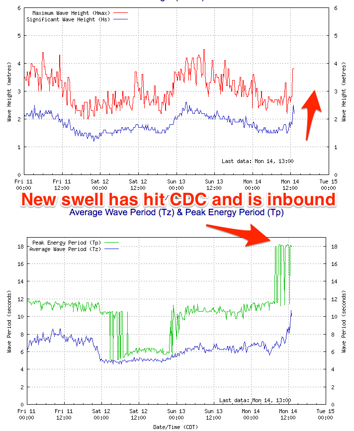
Today the Mid is back to 0.5ft with cleaner waves down South and a small peaky 2ft of southerly swell. A new inconsistent W/SW groundswell has hit the Cape du Couedic wave buoy and we should see this kicking this afternoon, providing inconsistent 1ft to maybe 2ft sets on the Mid Coast by late today and 2-3ft lines of groundswell off Middleton.
Today’s Forecaster Notes are brought to you by Rip Curl
This week and weekend (Jan 15 - 20)
 This afternoon's W/SW groundswell was generated late last week and into Saturday by a strong but distant storm that developed west-southwest of WA.
As touched on above the swell has arrived on the Cape du Couedic wave buoy and we should see the swell kicking later to an inconsistent 1ft to maybe 2ft on the Mid Coast and 2-3ft off Middleton. The swell is due to ease back from a similar size on both coasts tomorrow morning with local offshore winds (N/NE South Coast and E/NE on the Mid) giving into afternoon sea breezes ahead of a slightly stronger change into the evening as a surface trough slips east.
Wednesday will be smaller and conditions a bit hit and miss with a morning E/NE breeze down South but likely only a small 2ft wave off Middleton, 0.5-1ft on the Mid Coast.
Thursday is likely the better of the two with a better NW offshore down South, variable on the Mid and a small new mid-period W/SW swell.
The swell will be best for swell magnets, generated by a weak front currently passing under WA. It may be seen late Wednesday but Thursday morning is a better chance with tiny 1ft waves on the Mid Coast and 2ft sets off Middleton. A S'ly change is likely mid-morning so try and surf early if heading down South.
The change will create poor conditions Friday with S'ly winds and a tiny easing swell, poorer Saturday with a stronger S'ly breeze.
Sunday isn't looking any better as winds tend more E/SE-SE but with no decent swell.
Longer term a new long-period SW groundswell is Tuesday next week, produced by a small, tight though intense low forming around the Heard Island region mid-week. The swell looks inconsistent and out of the SW, peaking Tuesday with a favourable NE offshore wind, but we'll have a closer look at this Wednesday.


Comments
Port Augusta just reached 48.9 degrees.
Ceduna reached 42.8 degrees at 11:30am, Wuddina reached 45.4 degrees at 12:45pm.
And most of the northern inland (Coober Pedy, Tarcoola, Roxby, Marree etc) have all maxed out at 47-48 degrees.
Ah, those wonderful memories of cruising down the Eye Highway in a rusty Kingswood with vinyl seats and no air conditioning, and Led Zeppelin IV blasting out over tinny speakers.
Still some lovely lines pushing through the Mid Coast for the late session.
Air temps at Noarlunga were still 40 degrees at 6:30pm! Bloody hell.
Yes we didn’t need air cond in the 70-80’s
Funny that ...
Can’t do 30C on the Goldie now without polar air from the vents .
The caves at Caves used to be a sanctuary during those summer Cactus trips LoL