Small W/SW swell pulses, mostly teasing the Mid Coast
South Australian Forecast by Craig Brokensha (issued Friday 11th January)
Best Days: Mid Coast for keen surfers Sunday, Mid Coast late Monday, both coasts Tuesday morning
Recap
Tiny waves yesterday morning on the Mid Coast, pulsing a little into the afternoon but with sea breezes. The South Coast continued to offer plenty of size but conditions were lumpy and peaky with a morning E/NE breeze.
Today started fairly morning sick but conditions have since straightened right up with a moderate to fresh offshore wind and good 3ft waves off Middleton. Winds should remain good until around mid-afternoon when weak sea breezes are likely to kick in.
Today’s Forecaster Notes are brought to you by Rip Curl
This weekend and next week (Jan 12 - 18)
A surface trough is currently moving in from the west, and this will push through proper early tomorrow morning, bringing a fresh and gusty S/SE breeze, strengthening through the afternoon. This will kick up a poor quality S/SE windswell which will then ease back through Sunday but with persistent SE tending S/SE winds.
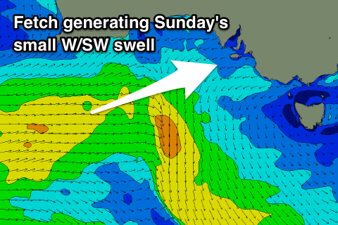
Our tiny W/SW swell for Sunday is still on track, with a weak but broad fetch of strong W/SW winds currently being projected through our western swell window, with the front forecast to weaken south of us this evening.
 1-1.5ft sets are due on the favourable parts of the tide across the Mid Coast Sunday, small and weak down South (mixed in with the windswell). Those SE tending S/SE winds will keep conditions clean all day in the gulf.
Monday morning will become cleaner down South with an E/NE ending NE offshore, but surf wise, there's nothing of size or power expected with a weak 1-1.5ft wave off Middleton. The Mid Coast will also be clean but tiny and to 0.5-1ft.
Into Monday afternoon we should see a new W/SW groundswell pushing in to the Mid Coast, peaking overnight and easing Tuesday.
The frontal system generating this will be distant, forming west-southwest of WA and only being short-lived with an elongated fetch of strong to gale-force W/SW winds, with a burst of severe-gale core winds at the head of the front.
This will produce a small W/SW groundswell for late afternoon Monday and Tuesday morning. The Mid Coast should kick to 1ft to maybe 2ft by dark, easing from a similar size on Tuesday morning.
Middleton looks to offer inconsistent 2-3ft waves and conditions will be bumpy across both coasts with afternoon sea breezes Monday, tending S/SE late on the Mid Coast, while Tuesday looks fun with an E/NE-NE breeze before sea breezes kick in again.
Beyond this swell there's nothing too significant on the cards. Winds look onshore for the South Coast for the most part and we may see a small W/SW swell for the Mid late week, but more on this Monday. Have a great weekend!

