One day to hone in on this period
South Australian Forecast by Craig Brokensha (issued Wednesday 9th January)
Best Days: Keen surfers South Coast tomorrow mid-late morning, South Coast Friday until mid-late afternoon, Mid Coast keen surfers Sunday
Recap
The swell kicked in large and strong out of the S/SW later Monday with Tuesday morning still seeing plenty of size across the South Coast. The Chiton region was best through the morning with light onshore breezes. The Mid Coast saw 1-1.5ft sets once the early morning high tide dropped.
Today we're back to 0.5-1ft waves on the Mid Coast and the South Coast was still seeing plenty of size but average conditions with a S/SE breeze.
Today’s Forecaster Notes are brought to you by Rip Curl
This week and weekend (Jan 10 - 13)
A new mid-period SW swell is due this afternoon, generated by a relatively weak but decent front pushing under the Bight and through our swell window yesterday.
The swell will likely just steady wave heights through this afternoon and tomorrow morning, with Middleton hanging in at 3ft, easing from a similar size tomorrow morning.
The Mid Coast should see 1ft+ sets this afternoon before easing back from 1ft tomorrow morning.
Winds will improve a touch across the South Coast, though conditions will still be peaky and mostly average with an E'ly tending E/NE breeze before sea breezes kick in.
 A secondary weaker but broad front moving through our southern swell window today should keep wave heights just up enough into Friday morning to create really fun surf as winds swing offshore.
Middleton is likely to be 2ft+ with 3ft sets likely down towards Cliffs, better at Waits and Parsons and with a N/NE offshore that is now due to tend N/NW into the early afternoon and W'ly late afternoon. This should keep conditions clean most of the day opening up plenty of time to get two surfs in.
I'd be advised to make the most of Friday as the weekend is looking poor as a deep surface trough moves in from the west, bringing strengthening S/SE winds and a poor increase in S'ly windswell.
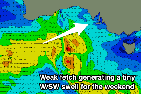
The Mid Coast should see a tiny W/SW swell on Sunday (possibly showing later Saturday)? as a weak mid-latitude front pushes under WA's South Coast. Size wise we're only looking at sets to 1-1.5ft on the favourable parts of the tide and with favourable SE offshore winds.
Into next week we may see a better long-range and inconsistent W/SW groundswell for later Monday and more so Tuesday, generated by a broad and strong but distant storm firing up west-southwest of WA.
Winds at this stage look tricky, but check back here on Friday for more on this.

