Make the most of the windows this week
South Australian Forecast by Craig Brokensha (issued Monday 7th January)
Best Days: South Coast keen surfers tomorrow morning, Thursday mid-late morning and Friday until mid-afternoon, tiny beginner peelers on the Mid Coast tomorrow, Wednesday, early Thursday
Recap
A strong pulse of new W/SW groundswell through Saturday with workable weak onshore winds across the Mid Coast and easy 3ft sets. The swell dropped rapidly overnight while cleaning up leaving small to tiny sets which is a shame seeing the size even late Saturday.
The South Coast was bumpy and building in size through Saturday with waves for keen surfers, cleaner Sunday morning with a more variable breeze but smaller fading surf.
Today is smaller with average onshore winds down South, clean but tiny on the Mid.
Today’s Forecaster Notes are brought to you by Rip Curl
This week and weekend (Jan 8 - 13)
Later today we should see a good long-period S/SW groundswell building, peaking early tomorrow, generated by a strong and slow moving polar low since late last week.
Satellite observations (which are patchy owing to the US Government Shutdown) show a good fetch of severe-gale W/SW winds aimed through our south-western swell window, and this should have been the case since late last week through the weekend.
The low is currently passing under Tassie, east of our swell window, and we're seeing the swell building strongly off Tasmania's Cape Sorell, with it likely to show at Cape du Couedic in the coming hours.
A late pulse of size is due down South, with a peak till due tomorrow morning with Middleton offering solid 4-5ft sets, with 1ft+ peaks on the Mid Coast.
 Unfortunately our onshore winds for the South Coast are still on the cards, with a moderate S'ly breeze (OK for keen surfers) due to freshen out of the S/SW during the day. The Mid Coast will be clean with a SE offshore ahead of S/SW sea breezes.
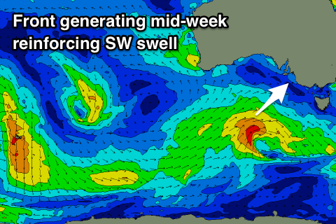
Wednesday morning will be smaller down South and back to 3ft or so off Middleton under average S/SE tending S'ly winds, but a new reinforcing mid-period SW swell is due to arrive during the later morning.
This is being generated by a weak frontal system that's currently south of WA and projecting through our south-western swell window, staying south of the Bight.
Winds won't really reach gale-force and we're only likely to see Middleton persisting at a weaker 3ft into the afternoon with a continuation of 1ft+ sets on the Mid Coast, with easing surf from 2-3ft and 1ft respectively Thursday morning.
Conditions look to improve slightly down South on Thursday morning with an E/NE breeze, while Friday will be cleanest with a N/NE offshore and Middleton should still be 2ft+, giving into afternoon sea breezes.
Winds look to revert back to the S/SE and with strength on Saturday as a deep trough moves across us followed by a strong high. Swell wise there's nothing significant due to next week and with generally onshore winds.
Therefore while not great this week, make the most of the swell on offer.

