Larger W/SW swell energy, though winds have changed
South Australian Forecast by Craig Brokensha (issued Wednesday 2nd January)
Best Days: Both coasts tomorrow (Mid Coast AM and South Coast from mid-morning), South Coast Saturday morning (keen surfers Mid Coast), Mid Coast Sunday and Monday
Recap
Fun sets to 1-2ft hanging in on the Mid Coast magnets yesterday morning, poor into the afternoon and tiny with sea breezes. The South Coast was an average 2-3ft or so, while today we've seen a new W/SW swell building across both coasts,
The Mid was 1-1.5ft and nearly 2ft at magnets, while the South Coast a workable and bumpy 2-3ft waves for keen surfers. The swell should strengthen in period and size this afternoon with sets to 2ft expected on the Mid Coast and 3-4ft off Middleton but with sea breezes. Winds should tend S/SE late, cleaning up the Mid.
Dawn lines on the Mid this morning..

Today’s Forecaster Notes are brought to you by Rip Curl
This week and weekend (Jan 3 - 6)
The strong frontal progression responsible for today's building and strengthening W/SW swell is now passing under Tassie and with this we'll see a SW groundswell component for early tomorrow, easing through the day.
The Mid Coast should see 1-2ft sets during the morning, with Middleton coming in at 3-4ft, but the main point is that winds will finally swing offshore for the South Coast.
An approaching mid-latitude low will steer winds N/NE through the morning down South (E/NE early), tending variable into the early afternoon ahead of late sea breezes.
 The Mid Coast should be clean with E/NE tending NE winds.
The timing off a change associated with the mid-latitude low has been pushed to dawn Friday morning. There's an outside chance you could get half an hour of clean conditions at dawn but it's not worth driving for.
The Mid Coast will be tiny and also bumpy with the fresh S/SW breeze, so all in all give Friday a miss.
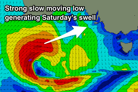
We've got much better prospects for the weekend as a large W/SW groundswell fills in from the intense mid-latitude low.
The low has currently formed west-southwest of WA and will track slowly east-southeast through our western swell window, generating a fetch of gale to near severe-gale W/SW winds.
As the low continues dipping east-southeast it will move more into the South Coast's swell window, with some better SW groundswell due on the backside of the swell event.
The W/SW groundswell is due to fill in overnight Friday with a peak through the day Saturday to a strong 3ft on the sets across the Mid Coast magnets, with Middleton building to 3-4ft later in the day. Winds have unfortunately changed for Saturday as a secondary weaker frontal system is now expected to race in from the west.
There's an outside chance for a dawn variable breeze, but we'll confirm this Friday, but it'll likely be onshore with increasing W/SW winds on the Mid (W/NW down South) as the front pushes in.
Sunday will see winds swing back to the S/SE-SE across the Mid Coast and Saturday's front will keep wave heights up to a good 2-3ft, with Middleton hanging in at 3-4ft.
Monday looks good again for the Mid Coast with swell easing from 2ft with offshore SE winds, still poor down South.
Longer term our good long-period SW groundswell for Tuesday is still on track, produced by a vigorous polar low, but with S/SE winds it will go to waste, with the Mid Coast only being tiny. More on this Friday.


Comments
Great LAGO conditions late today and a decent swell rolling in at exposed spots.