Good W/SW swells inbound for the Mid Coast
South Australian Forecast by Craig Brokensha (issued Friday 28th December)
Best Days: Mid Coast Sunday, Monday, Tuesday for super keen surfers, Wednesday afternoon, both coasts Thursday
Recap
Clean fun waves across most locations yesterday morning with a hot offshore wind, giving into a cooler afternoon S/SW change.
The Mid Coast was clean but tiny and to 1ft through the morning, effectively flat today. The South Coast was tiny and only surfable at Waits and Parsons.
Today’s Forecaster Notes are brought to you by Rip Curl
This weekend and next week (Dec 29 – Jan 3)
An onshore change is pushing in from the west and once this moves in we'll be in for a run of average S/SE winds across the South Coast.
The Mid Coast will thankfully provide good surfing options with a series of W/SW swells due to fill in from Sunday.
 Firstly tomorrow, and a small new SW swell is due off a weak front that moved under the country mid-week, with small 2ft sets due off Middleton with 1ft peelers on the Mid Coast. That fresh S/SE wind will create poor conditions down South, cleanish on the Mid.
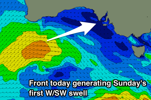
Our better W/SW swell for Sunday is still on track with a great mid-latitude front that's currently passing under WA's South Coast generating a good fetch of strong to near gale-force W/SW winds through our western swell window.
The front will dip east-southeast while shrinking in scope but intensifying slightly, producing an additional fetch of W/SW gales in the South Coast's south-western swell window.
A good W/SW-SW swell is expected to fill in Sunday with super fun 2ft surf on the Mid Coast (if not for the rare bigger one) and 3ft sets off Middleton. Winds will hang from the S/SE, favouring the Mid Coast all day.
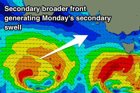
A secondary slightly stronger and broader but more southerly positioned front will push under the country and Bight tomorrow, weakening and dipping east-southeast Sunday, producing a good reinforcing SW swell for Monday morning.
 The Mid Coast looks to persist around 2ft with 3ft+ sets off Middleton but those pesky S/SE winds will only favour the Mid Coast.
The swell is due to ease temporarily into Tuesday as onshore S/SE tending SW winds continue to create average conditions down South, clean on the Mid early and with 1-1-1.5ft leftovers.
As talked about in Wednesday's update, a slower moving and broader frontal progression through the weekend and early next week should produce a prolonged mid-period SW tending stronger groundswell event.
An elongated and slow moving fetch of strong to gale-force W/SW winds will strengthen south-west of us on Monday with the mid-period energy due Wednesday morning ahead of the groundswell into the late afternoon and Thursday morning.
Size wise Middleton should build to an easy 4ft into the late afternoon and evening Wednesday but with SE tending S/SE winds, with building sets to 2ft on the Mid Coast, while Thursday looks the pick with an offshore finally kicking in from the N/NE with surf easing from a similar size to Wednesday evening. The models slightly diverge on this wind outlook so check back here Monday for confirmation on Wednesday's and Thursday's winds. Have a great weekend!


Comments
Lovely waves on the Mid this morning.


Not as good as that, but it was a fun sesh late morning on the Mid today. Decent swell.
Good to see the swells come in really nicely.