Poor surf until next week
South Australian Forecast by Craig Brokensha (issued Wednesday 19th December)
Best Days: South Coast Monday and Wednesday morning
Recap
Average though improving waves for desperate surfers across the South Coast yesterday with workable winds until sea breezes kicked in late morning, backing off for a period through the afternoon. The Mid Coast was tiny to flat.
Early this morning the South Coast was clean, but winds shifted back onshore shortly after dawn along with a small leftover swell. With a dynamic and deepening trough drifting across us we'll see winds hanging from the E/NE-E/SE ahead of a fresher S/SE'ly later this afternoon.
Today’s Forecaster Notes are brought to you by Rip Curl
This week and next week (Dec 20 - 28)
The end of this week and weekend are looking very poor, but there's better potential into next week.
Once the deepening surface trough moves across us later this afternoon we'll see poor and strong S'ly winds projected into the South Coast tomorrow, creating choppy conditions and kicking up a small weak S'ly windswell building to 2-3ft or so. The Mid Coast will remain flat.
This windswell will ease back through Friday mixed in with a small background SW groundswell to 2ft off Middleton and with average and fresh S'ly tending S/SW winds.
Weaker though persistent S'ly winds are due to persist Saturday as the surf drops from a small 1-2ft off Middleton, flat on the Mid Coast.
Sunday will be clean with a light E/NE tending NE offshore wind, but there'll be no decent swell left at all, tiny off Middleton and 2ft max at Waits and Parsons.
Of greater importance is some stronger and closer frontal activity that's forecast to develop under the country on the weekend.
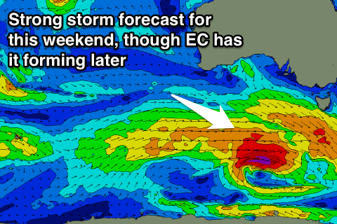
A relatively weak mid-latitude front moving in from the south-east Indian Ocean is expected to strengthen south-west of WA Friday afternoon and evening, generating a fetch of strong pre-frontal W/NW winds, followed by post-frontal gale-force W/SW winds, strongest when south of us Saturday evening and Sunday.
 This will be the followed by a broad though weaker front, generating strong W/SW winds on its tail.
The track and aim of the initial strong storm isn't ideal and EC has it deepening later in our swell window (so I've put a buffer on the expected size), but we should see a good new SW groundswell building through Monday, easing slowly through Tuesday and Wednesday.
Middleton should build through Monday to 3ft+ into the late afternoon and evening (1ft on the Mid Coast), easing back from a similar size on Tuesday (Christmas Day), while hanging in at 3ft Wednesday. Winds look good Monday morning and offshore from the N/NE, giving into a late shallow W/SW change, back to the S/SE on Tuesday and likely E/NE Wednesday morning.
Check back Friday for a better look at next week's swell when the models will be more aligned regarding the expected size.

