Easing stormy swell with one decent follow up swell
South Australian Forecast by Craig Brokensha (issued Friday 14th December)
Best Days: No great days, South Coast keen and experienced surfers tomorrow morning, Mid Coast Monday for small peelers
Recap
Strengthening onshore winds and building stormy swells across both coasts yesterday, large into the afternon down South.
Today the swell has peaked on the South Coast with very large and stormy conditions under gale-force winds, while the Mid Coast was a choppy and semi-stormy 2-3ft. Winds have since shifted offshore on the Mid a bit earlier than expected, creating fun easing surf in the 2ft+ range across exposed breaks. The swell will continue to ease through the day with it being only local, while winds have also eased and shifted down South along with a drop in swell.

Today’s Forecaster Notes are brought to you by Rip Curl
This weekend and next week (Dec 15 - 21)
We've weathered the worst of the strong and broad mid-latitude low that's sitting across the south-east of the country, but we'll continue to see poor conditions tomorrow as it continues to weaken.
A moderate S/SE breeze may tend variable for a period through the morning before tending more S/SW and increasing through the afternoon. This will create clean conditions on the Mid but it'll be tiny and 1ft max.
The South Coast is expected to still be solid and easing rapidly from 3-5ft at exposed breaks, down to 3ft into the afternoon. While onshore it should be workable through the morning.
Sunday morning will be smaller again and back to 2ft or so but winds look to still be onshore and out of the SW, creating average conditions (especially with the weak windswell).
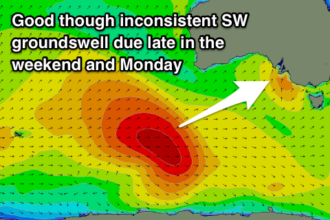
 Our new long-period and inconsistent SW groundswell for later in the afternoon and Monday is still on track, with the storm that generated it currently weakening south of WA.
During the middle of this week, a fetch of severe-gale to storm-force W'ly winds were produced, with the groundswell due to build Sunday afternoon, reaching 3ft across Middleton and 1-1.5ft on the Mid Coast, peaking Monday to 3-4ft and 1-2ft respectively on the favourable parts of the tide. There'll be a bit of a wait between the sets though.
Winds will unfortunately remain onshore for the South Coast and S/SE as a high pressure ridge moves in slowly from the west. Tuesday looks a bit cleaner but not great with a moderate to fresh E/NE breeze, ahead of sea breezes.
A weak low moving in from the west looks to bring offshore NW winds Wednesday morning but there isn't expected to be hardly any swell on offer.
Unfortunately the longer term outlook isn't great at all with the high putting a block across our main swell windows, resulting in no size and persistent S/SE winds. More on this Monday. Have a great weekend!

