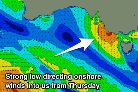
Improving conditions before deteriorating later week
South Australian Forecast by Craig Brokensha (issued Monday 10th December)
Best Days: South Coast keen surfers tomorrow mid-morning to early afternoon, South Coast swell magnets Wednesday morning
Recap
Poor onshore waves across the South Coast all weekend, with a touch more size today, but under the expected 3-4ft, with smaller 2-3ft sets off Middleton. The Mid Coast was cleaner but Friday's pulse of swell dropped back to the tiny range Saturday, while a new swell Sunday afternoon pulsed to 2ft, but the peak in size due this morning wasn't sighted. Instead we've seen tiny 1ft+ leftovers.
Today’s Forecaster Notes are brought to you by Rip Curl
This week and weekend (Dec 11 - 16)
While today's swell has come in under forecast expectations, we've got some small reinforcing energy due to keep wave heights up through tomorrow, generated by a weak front pushing under WA on the weekend.
The Mid Coast will be around 1ft for the most part tomorrow, with 1.5ft sets on the favourable parts of the tide, with Middleton easing back from 2ft to occasionally 3ft.
Winds will improve and tend E/NE through the morning across the South Coast, but conditions will still be lumpy and peaky, especially early morning.
A temporary low point in swell is expected Wednesday morning back to 2ft off Middleton with a great N'ly offshore wind, while the Mid Coast will be tiny.
Winds will swing N/NW ahead of a W/SW change through the afternoon as a deepening surface trough moves in from the west.
 This will be around the same time a new SW groundswell starts to fill in, ahead of a peak Thursday morning.
This was also generated over the weekend by a strong polar front firing up between Heard Island and WA, producing a good fetch of W/SW gales, with stronger core winds. The storm is currently weakening south of WA, and we should see a late pulse of size Wednesday afternoon to 3ft off Middleton and hopefully 2ft on the Mid Coast, holding Thursday.
Unfortunately the deepening trough will continue east, bringing strong S/SW winds to both coasts and a building windswell down South as a low pressure centre forms, stalling across inland NSW and Victoria. The Mid Coast will also build in size Thursday with a stormy 2-3ft of windswell into the afternoon.
Down South we're due to see moderate to large levels of S'ly windswell Friday (easing stormy 2-3ft waves on the Mid) with those strong S/SW winds, easing off slowly into the weekend as the low slowly weakens. Unfortunately we'll continue to see onshore S'ly winds the entire time, creating poor surfing conditions.
Longer term a good new long-period SW groundswell is due to build Sunday afternoon and peak Monday, produced by a strong storm developing in the Heard Island region tomorrow. Winds look SE and only favourable for the Mid Coast, which will be tiny and around 1ft+, but we'll review this again Wednesday.

