Large swell inbound, cleanest as it eases
South Australian Forecast by Craig Brokensha (issued Friday 30th November)
Best Days: South Coast tomorrow, protected spots Monday morning South Coast, both coasts Tuesday, South Coast Wednesday morning
Recap
Another poor day of surf yesterday, but we've got a new pulse of swell and favourable winds across both coasts this morning, 0.5-1ft on the Mid and a better 2-3ft off Middleton and Goolwa down South.
A further spike in W/SW swell is due this afternoon and this may pulse the Mid Coast to 1-2ft and 3ft+ off Middleton but with sea breezes. The Mid however should see winds going back to the SE late.
Today’s Forecaster Notes are brought to you by Rip Curl
This weekend and next week (Dec 1 - 7)
Later today's pulse of swell will hold into tomorrow morning before easing off slowly into the afternoon.
Middleton should see good 3ft+ waves (4ft sets off Middleton) with 1-2ft sets on the favourable parts of the tide across the Mid Coast.
Winds will only be favourable for the South Coast though with an approaching low bringing gusty N/NE offshore winds early-mid morning, shifting N/NW and possibly holding until dark. There's a strong W/SW change due around dark, but you'll have plenty of time to surf before then.
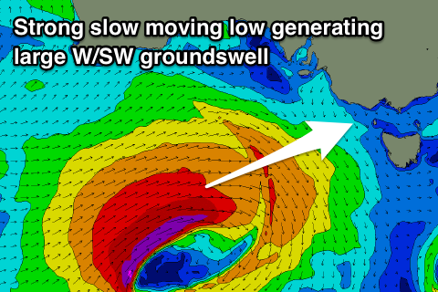
 Into Sunday our large W/SW-SW groundswell is still on track, with it being generated by a vigorous low that's formed south-west of WA, with a fetch of severe-gale W/SW winds due to be projected east through our western swell window today before the low stalls slightly south of the Bight tomorrow and then progresses east again into Sunday under us while weakening.
This will generate a large long-period W/SW-SW groundswell that's expected to arrive through the day Sunday, building to a large 5-6ft off Middleton into the afternoon, with the Mid Coast kicking to 2-3ft but with a dodge-tide.
Winds will be generally fresh out of the W/SW, though the Victor region will likely see early W/NW winds.
Into Monday we should see W/NW winds through the morning again around Victor, though tending W/SW through the afternoon as a secondary front piggy-backs on top of the low, generating a reinforcing mid-period SW swell for the afternoon.
Size wise, Middleton is expected to ease back a touch to 4-6ft, easing a little more later, but more so Tuesday, while the Mid Coast will see waves mostly to 2ft+, holding all day.
As the swell eases Tuesday we should see the Mid Coast clean up with an E/SE offshore, more variable down South and with easing sets from 1-2ft, down from 3-5ft off Middleton.
Wednesday looks straighter down South with a better N/NE offshore though smaller surf.
Longer term a fun new W/SW groundswell is on the cards for late week/next weekend but we'll have a closer look at this Monday. Have a great weekend!


Comments
Lovely lil' afternoon lines across the Mid Coast. Just five crew out at Trigs for the late session!
