Smaller swells with improving conditions from Sunday
South Australian Forecast by Craig Brokensha (issued Friday 16th November)
Best Days: Sunday mid-morning through mid-afternoon down South, Monday down South, keen surfers later Wednesday/Thursday morning Mid Coast
Recap
Onshore winds across both coasts yesterday with a tiny windswell on the Mid, strengthening into better groundswell lines through the afternoon with the arrival of a new groundswell.
The South Coast was a bit of a mess with onshore winds, but building surf into the afternoon.
This morning the surf is much better across all locations with clean 1ft surf on the Mid, much better down South with a variable breeze and good 3ft+ sets off Middleton. Winds have since shifted back onshore creating average conditions.
Today’s Forecaster Notes are brought to you by Rip Curl
This weekend and next week (Nov 17 - 23)
Today's swell will ease off this afternoon and continue to drop through tomorrow, but we'll see some fun size reinforcing SW swell filling in, ahead of a slightly stronger pulse for Sunday.
Winds will remain average tomorrow and out of the SE-E/SE down South ahead of fresher S/SE sea breezes.
The strongest pulse for Sunday was generated by a relatively weak polar low forming east of Heard Island through the middle of this week, while some additional mid-period energy is currently being generated by a broad fetch of strong W/NW winds south of WA.
Size wise Middleton looks to come in at 2ft to occasionally 3ft through tomorrow, with waves either side of 1ft on the Mid Coast.
Sunday looks the pick of the weekend as winds swing around to the NE through the morning (E/NE early and not ideal) along with the stronger groundswell coming in more around 3ft on the sets across Middleton. The Mid looks to remain around that 1ft range, ebbing and pulsing on each side of the tide.
Winds should hold until the early-mid afternoon before sea breezes finally kick in.
Monday will become a touch smaller with easing 2ft to occasionally 3ft sets off Middleton but with a great moderate to fresh N/NE offshore, tending W/NW into the afternoon, tiny on the Mid Coast.
 Into Monday afternoon and Tuesday morning a very inconsistent reinforcing long-range SW groundswell is due to fill in, produced by a stronger but more distant polar low in the Heard Island the last couple of days.
Size wise, lully 2ft+ sets are due off Middleton, tiny on the Mid Coast. Winds will unfortunately be poor with a SW change expected early in the morning Tuesday.
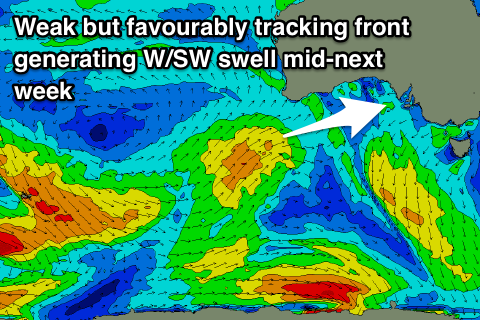
This change will be linked to a weakening mid-latitude front clipping the state, spawning off a stronger front come weak mid-latitude low pushing under WA and into the Bight Sunday/Monday.
A fun new W/SW swell is expected off this front on Wednesday, building through the afternoon and reaching 2ft+ on the Mid Coast, and easing from a similar size on Thursday morning. The South Coast won't see much in the way of size and persistent SW winds will continue to cause issues.
Winds look to improve later in the week and into next weekend along with a possible fun new S/SW groundswell, but more on this Monday. Have a great weekend!

