Average few days, improving from Sunday
South Australian Forecast by Craig Brokensha (issued Wednesday 14th November)
Best Days: Sunday South Coast, Monday South Coast, tiny beginner waves on the Mid Coast most days
Recap
A very small window of OK winds at dawn yesterday across the South Coast before giving into an onshore change creating poor conditions for the rest of the day. The Mid Coast was tiny with a small increase in windswell through the afternoon.
Today there was a small window of OK conditions down South again with 2-3ft sets off Middleton, but winds have since shifted onshore, and the Mid Coast is tiny and bumpy. Premium subscribers now have access to our new Goolwa cam which looks over Cliffs and down towards Day St, giving a great indication of the size and conditions. Click through here for the vision.
Today’s Forecaster Notes are brought to you by Rip Curl
This week and weekend (Nov 15 - 18)
We've got an average run of conditions across the South Coast to end off the week, spoiling a good new SW groundswell.
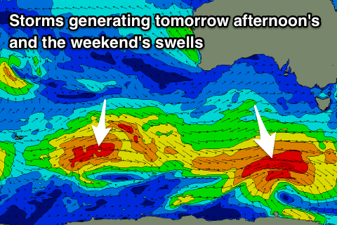
The final touches of this groundswell are being generated by the polar low that's currently south-west of Tassie, with it due to build through tomorrow and reach 3ft to occasionally 4ft off Middleton into the afternoon. The Mid should see tiny 1ft+ waves, with both coasts easing back in size from 1ft and 3ft+ Friday morning.
As touched on above, a high will ridge in from the west through the day today, bringing moderate to fresh S/SE winds.
 Friday looks to see moderate S/SW tending gusty S'ly winds, with a very slim chance for an early variable wind across the South Coast.
We'll see a slightly better E/SE breeze across the South Coast Saturday morning, though conditions will remain very average.
We'll also see some new mid-period swell fill in, with a secondary pulse for Sunday.
These mid-period swells will be generated by fetches of strong to gale-force W/SW fetches in our far-medium range swell windows south-west of WA, with weaker fetches of strong W/NW winds moving in closer to us, south-west of Tassie on Friday.
Size wise Middleton should hang in around 2ft to occasionally 3ft Saturday and a more convincing though inconsistent 3ft on Sunday with waves either side of 1ft on the Mid Coast.
Conditions will improve considerably on Sunday with a developing NE offshore through the morning, variable into the afternoon and then great Monday with a fresh N/NE tending NW breeze.
Longer term it looks like we'll see winds return to the west through next week as a mid-latitude low pushes in through the Bight, but more on this Friday.


Comments
I just checked the Swellnet app but can't see the Trigs, Christies and Goolwa cams. Will they be accessible via the app soon?
We're working on that ASAP - for now please access via the mobile website (which works a little better IMO).
A brand new App will be launched next year!
Thanks Ben. Is that also the case for the Forecaster Notes? I can't seem to access these in the app but can via mobile website.
Goolwa cam looks great!
I can't seem to select it as a Multi Camtho.....perhaps because it is not yet on your Surfcams menu?
Hmm, that's a tech question for our developer Jono... who's in Indo ATM. We'll have fixed ASAP.
No worries Ben - as a workaround I have selected Goolwa cam as my favourite as I can always select Middleton from the menu if I want to see what's going on there. Cheers
Goolwa Cam should be renamed Cliffs Cam.
Does it really matter? The cam looks across the Goolwa stretch, and it's a more easily identifiable location (for website navigation, and Google searches). There's no discernible difference in surf between Cliffs and Goolwa; theoretically a fraction more size, but you'd be hard pressed to measure it. Certainly no indentifiable change in surf spot anyway (compared to The Dump and Chiton, for example). Goolwa is part of the South Coast vernacular - you check Middleton, then head down to Goolwa, or around to Waits and Parsons.
Well done with the new cam. We end up surfing Cliffs a lot when on that side and the cam gives a great wide view.