Large surf over the weekend, with another large swell early next week
South Australian Forecast by Craig Brokensha (issued Friday 2nd November)
Best Days: Keen surfers early tomorrow down South in protected spots, both coasts Sunday, South Coast Monday morning
Recap
Fun clean waves across the South Coast yesterday after early variable and slightly morning sick conditions. Best at Waits and Parsons for the most size. The Mid Coast was tiny though kicked a little into the afternoon.
Overnight and early this morning we saw multiple storm cells pushing through and I don't think many people had a good sleep.
The South Coast was clean again but only small, with tiny bumpy waves on the Mid Coast. These storms are linked to an approaching cold front through the Bight and large surf this weekend.
Today’s Forecaster Notes are brought to you by Rip Curl
This weekend and next week (Nov 3 - 9)
We've got a very active forecast period ahead owing to a strong node of the Long Wave Trough developing across the Bight and moving slowly east through the weekend and next week.
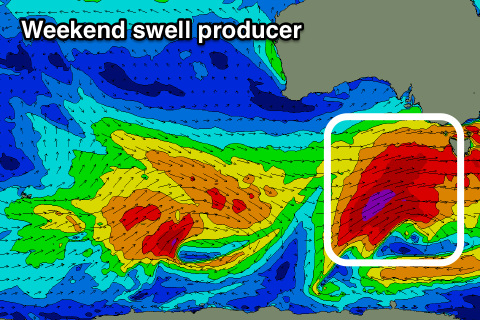
 Currently a vigorous cold front is passing under WA and through the Bight, generating a fetch of W/SW gales in our western swell window.
During today we'll see this storm broaden and strengthen while on approach from the west, with a great fetch of W/SW gales projected through our south-western swell windows, with the front moving through proper this afternoon.
A large W/SW tending SW groundswell will fill in tomorrow in the wake of this front, with a rapid increase in size through the day up to 4-6ft off Middleton with easy 2-3ft sets on the Mid Coast.
Winds are an issue tomorrow and fresh onshore out of the SW across all locations though easing through the day and tending S/SE late on the Mid Coast. The Victor region is likely to see an early W'ly wind for keen surfers in protected spots.
Our reinforcing pulse of large S/SW groundswell for Sunday has been downgraded a touch, with a core fetch of severe-gale SW winds being projected up through our southern swell window on top an active sea state. This is a touch weaker than the earlier forecast storm-force fetch on Wednesday.
In any case Middleton should hang around 5-6ft most of the day before easing later while the Mid Coast looks to ease back from 2-3ft.
Conditions are still looking great for both locations with a N'ly tending N/NW and then variable wind down South, NE tending N and then variable wind on the Mid Coast.
Monday looks good again down South but the swell will be on the ease from the 3ft+ range off Middleton with a NW offshore as another front approaches, bumpy and small on the Mid Coast.
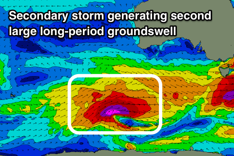
 This front will be linked to a secondary vigorous polar storm being steered up towards us under the influence of the Long Wave Trough.
The storm will develop south-west of WA tomorrow morning, with a great fetch of severe-gal to storm-force W/SW winds projected through our south-western swell window before the storm stalls and weakens south-west of us Sunday evening.
As it stalls a secondary weaker front will spawn off its tail and push north through the Bight Monday and then across towards us Tuesday, bringing an onshore change and additional mid-period W/SW swell.
Middleton should see large 4-6ft sets on Tuesday morning easing through the day with a W/SW-SW breeze, while the Mid Coast looks to build to be around a small 1-2ft in the morning with an increase in windswell to 2ft+ later, and 2ft to occasionally 3ft sets on Wednesday.
Winds don't look like letting up on Wednesday and will remain onshore out of the W/SW-S/SW, but we'll have a closer look at this and the rest of the week on Monday. Have a great weekend!

