Large swells inbound with windows of good winds
South Australian Forecast by Craig Brokensha (issued Monday 29th October)
Best Days: South Coast tomorrow, Mid Coast later Saturday, both coasts Sunday, South Coast Monday morning
Recap
Good clean fun waves the last two mornings on the South Coast with surf in the 3ft range yesterday morning, back to 2-3ft this morning. The Mid Coast has hovered around 1ft, with the odd bigger one with the push of the incoming tide.
A new long-period SW groundswell due this afternoon has hit the Cape du Couedic wave buoy and should reach 3-4ft off Middleton with 1ft to possibly 2ft sets with the incoming tide on the Mid as winds tend back offshore late.
Today’s Forecaster Notes are brought to you by Rip Curl
This week and next week (Nov 1 - 9)
This afternoon's good pulse of new long-period SW groundswell will ease off slowly through the end of the week with great conditions tomorrow with a N'ly offshore, tending N/NW-NW through the afternoon and then variable late.
Middleton should ease back from 3ft or so, if not for the odd sneaky bigger one early morning, with 1ft+ waves on the Mid Coast.
An approaching cold front Friday will bring W/NW-NW winds early morning ahead of a fresh W/SW change into the afternoon. The South Coast will be small and back to 2ft off Middleton, while the Mid Coast looks to persist around 1ft+ with a small new mid-period W/SW swell and likely 1-1.5ft of windswell building into the evening with the W/SW change.
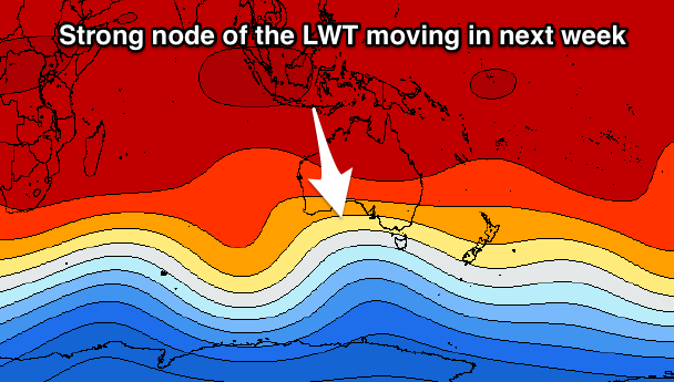
This cold front approaching from the south-west and associated large swell will be the first in a series of large strong swells owing to a strong node of the Long Wave Trough developing in the Bight and pushing slowly east towards Victoria.

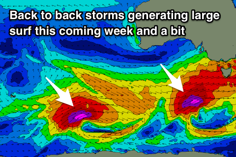
This first swell will be generated by a vigorous polar front projecting up towards WA, generating a fetch of W/SW gales in our western swell window today and tomorrow, but as the front pushes further east and south of the Bight, we'll see it strengthen and broaden.
A broad fetch of W/SW gales will be generated in our south-western swell window, directly south-west of us on Friday afternoon and evening, with core storm-force SW winds projected on top of this active sea state up through our southern swell window Friday evening and Saturday morning.
What we'll see is a moderate to large W/SW tending SW groundswell building through Saturday ahead of a large powerful long-period S/SW groundswell for Sunday.
Middleton should build to 4-6ft through the day Saturday, with the S/SW groundswell on Sunday coming in at a larger 6ft to possibly 8ft, especially at deep water reefs.
 The Mid Coast will see plenty of size and build to an easy 2-3ft, dropping slowly from a similar size on Sunday.
Unfortunately winds on Saturday will be onshore for all locations in the wake of Friday's change with SW winds. A strong high will move in through the afternoon and with this we should see winds tending S/SE later in the day, cleaning up the Mid Coast.
Sunday looks great across all locations with a NE offshore on the Mid and N/NE winds down South ahead of afternoon sea breezes.
The swell will continue to ease into Monday under a NW tending W/SW breeze ahead of another strong approaching cold front.
This cold front will start as a polar system, with a fetch of severe-gale W/SW winds generated south-west of WA over the weekend, generating a moderate to large long-period SW groundswell for Tuesday morning.
As this swell fills in though, we'll see the remnants of the storm pushing in across us, bringing mid-period swell energy and wind with it, but we'll have a closer look at this Friday.

