Poor weekend, better swells and winds next week
South Australian Forecast by Craig Brokensha (issued Friday 26th October)
Best Days: South Coast keen surfers Monday morning, South Coast Tuesday morning, Mid Coast Wednesday, South Coast Thursday morning
Recap
Cleaner though still fairly lumpy surf yesterday morning across the South Coast with a bit of size and light offshore winds ahead of a S’ly change mid-late morning. The Mid Coast was a super fun 2ft at dawn, dropping back through the morning and onshore into the afternoon.
This morning the swell has bottomed out on the Mid, with leftover and lumpy 2-3ft sets down South which has sincen improved a little and is best at swell magnets.
Today’s Forecaster Notes are brought to you by Rip Curl
This weekend and next week (Oct 27 – Nov 2)
This coming weekend isn’t looking too exciting at all.
Firstly winds are looking dicey and light to possibly moderate from the S’th tomorrow morning and secondly no new swell is due, with tiny fading sets off Middleton and small leftover waves at Waits and Parsons. The Mid Coast will become flat.
Sunday will start tiny again and with an E-E/NE wind, while a new inconsistent SW groundswell due later in the day will be met with afternoon sea breezes.
Monday and Tuesday are looking better with the SW groundswell arriving late Sunday, peaking through the morning ahead of a stronger reinforcing pulse later in the day, peaking Tuesday.
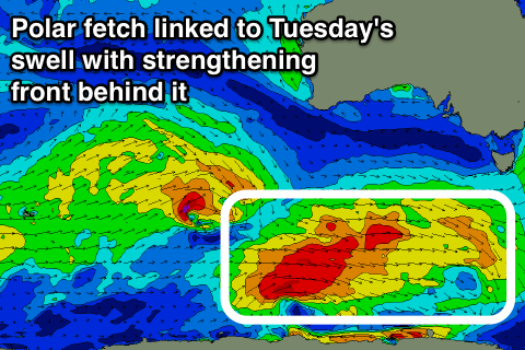
The first swell has been generated the last couple of days by a very slow moving and almost stalling fetch of strong to gale-force W’ly winds, east of Heard Island and south-west of Western Australia.
 As touched on in Wednesday’s notes, an infrequent 2-3ftt wave is due off Middleton with 1ft sets on the Mid Coast though a slightly stronger longer-period pulse of swell should be seen into the afternoon and Tuesday morning.
The source of this swell will be a less favourably aligned but stronger fetch of pre-frontal NW gales moving in through a similar area of the Southern Ocean, broadening while weakening south of the country on the weekend.
More consistent size to 3ft is likely, holding through Tuesday at a similar size, though only tiny and to 0.5-1ft on the Mid Coast.
Winds on Monday should tend light NE through the morning though there’ll probably still be a fair bit of lump, a bit better and straighter on Tuesday with N/NE winds through the morning.
Longer term a moderate sized SW groundswell is expected Wednesday as a strong frontal system deepens below the country early next week, generating a fetch of severe-gale to storm-force W/SW winds. A ridge of high pressure will move in bringing SE winds as the swell peaks, coming in at 3-5ft off Middleton and 1-2ft on the Mid, but we’ll review this on Monday. Have a great weekend!

