Increasing westerly activity, looking excellent one day next week
South Australian Forecast by Craig Brokensha (issued Friday 19th October)
Best Days: Later Saturday Mid Coast, both coasts Sunday, South Coast Monday morning, and Tuesday morning, both coasts Wednesday
Recap
Super fun waves across the South Coast yesterday morning with a W/NW breeze and good sized mix of swells, onshore into the afternoon but still decent. The Mid Coast clean most of the day though slow on the outgoing tide, improving with the push of the incoming tide as winds remained light and variable.
Today the swell has eased across both coasts, tiny on the Mid and small and best at Goolwa and Parsons with improving winds and conditions.
Today’s Forecaster Notes are brought to you by Rip Curl
This weekend and next week (Oct 20 – 26)
Tomorrow morning isn't looking too flash as today's swell continues to fade, mixed in with a new W/SW windswell from a strong but weakening front pushing across us later today.
Middleton may see weak 2ft sets while the Mid Coast looks to offer a junky 2ft of windswell along with fresh but easing onshore W/SW tending SW winds (W/NW early around Victor) across both coasts.
Our new stronger W/SW groundswell for the late afternoon from the initial stages of the low is still due, with a tight fetch of severe-gale W/SW winds forming south of WA yesterday afternoon with a couple of storm-force barbs picked up by satellite.
This low is now weakening while pushing towards us and tracking east-southeast, with the groundswell due to arrive tomorrow afternoon, being quite west in nature and building to a strong 3ft on the sets across the Mid Coast, while Middleton might not reach 3ft until dark.
Winds will still be lingering south-west across the Mid Coast but without too much strength, offering OK waves for the late.
Come Sunday the swell is due to ease back across the Mid Coast from 2-3ft, with easing 3ft+ waves off Middleton early.
Conditions will be much better across both coasts as an approaching front swings winds offshore from the N/NE down South, variable into the afternoon and NE tending N/NE and then variable on the Mid Coast.
Monday's mix of W/SW and SW groundswells are still on track, with a strong polar low forming south-southwest of WA yesterday afternoon and evening, generating a tight fetch of severe-gale to storm-force W/SW winds in our south-western swell window.
As this low weakens today, a great fetch of gale to severe-gale pre-frontal W/NW winds will move in from the Indian Ocean, under WA before quickly fading to the south-east, generating an additional W/SW groundswell.
Both swells should arrive around a similar time and peak Monday to a good 3ft+ off Middleton, with 2ft waves on the Mid Coast, with the possible set to 3ft on the favourable parts of the tide.
The only issue are the local winds, with yet another strong mid-latitude storm due to move in from the west, bringing freshening N/NE tending N/NW winds ahead of a strong W/SW change mid-afternoon.
A large W/SW groundswell will fill in behind this storm, with it being generated over the weekend and early next week.
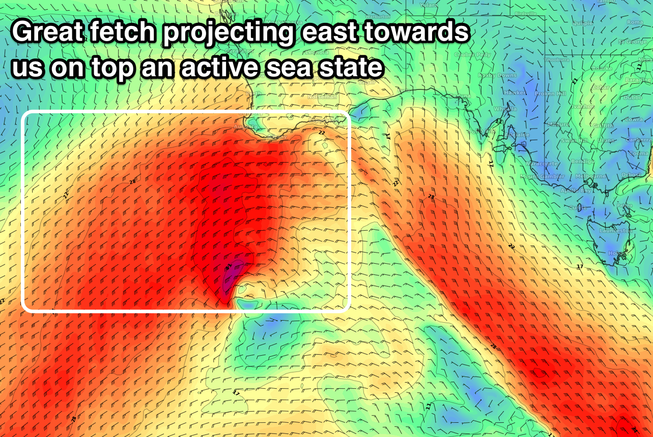
 A broad and strong fetch of W/SW-SW winds is due to move in behind the pre-frontal W/NW fetch generating Monday's swell, creating an active sea state for a stronger embedded front to project a fetch of W/SW gales up towards and then under WA, ideally through our western swell window.
The front will weaken slowly while contracting in scope and moving in across us Monday afternoon and evening.
What we should see is some solid mid-period W/SW swell for Tuesday morning ahead of the groundswell into the afternoon/evening, easing slowly Wednesday.
The Mid Coast should build from 2-3ft to 3ft to possibly 4ft by dark, easing from a similar size Wednesday, with the South Coast building to 4ft+ later in the day, peaking Wednesday morning to 4-5ft.
Winds should be OK for the South Coast Tuesday morning and out of the W/NW ahead of a SW tending S change as a high moves in, with E/NE winds on Wednesday with the peak of the swell. This should create excellent waves on the Mid Coast with the strong groundswell.
Check back here on Monday for an update on the expected sizes and winds through the middle to end of next week. Have a great weekend!


Comments
Good waves before the tide got to it this AM.