Great waves for both coasts this period
South Australian Forecast by Craig Brokensha (issued Wednesday 17th October)
Best Days: Thursday both regions, Friday morning swell magnets down South, later Saturday and Sunday both coasts, Monday morning South Coast
Recap
Tiny clean conditions yesterday morning across the South Coast, with a bumpy small increase in new swell later in the day. The Mid Coast saw building stormy surf from 2ft in the morning up to 3-4ft through the afternoon.
This morning the swell was stronger down South and coming in at 3ft off Middleton with workable winds for keen surfers, onshore and easing back to 2ft+ on the Mid Coast.
Today’s Forecaster Notes are brought to you by Rip Curl
This week and weekend (Oct 18 – 21)
Today's mix of swells, that being a small W/SW groundswell and more localised W/SW swell from the slow moving and weakening mid-latitude low sitting across us should ease this afternoon, replaced by a better long-period W/SW groundswell with a peak due tomorrow morning.
This was generated by a strong storm that formed south-west of WA over the weekend, and it has come in as expected across that state, with a peak due tomorrow to 2ft on the Mid Coast and 3ft+ along the Middleton stretch.
Conditions look to be favourable for both regions tomorrow with a light W/NW tending variable wind due across the South Coast ahead of late weak sea breezes, while the Mid Coast should see variable winds all day.
Come Friday as the W/SW groundswell eases from 2ft+ off Middleton and 1-1.5ft on the Mid Coast, an early fresh N/NE'ly will tend more N/NW through the day ahead of a gusty W/SW change, bringing a late increase in windswell across the Mid Coast.
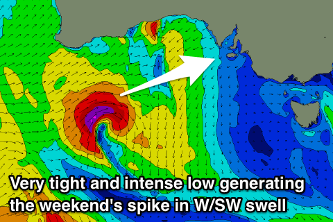
This change will be linked to a vigorous but weakening mid-latitude front pushing across us, with it generating a tight fetch of severe-gale W/SW winds under WA before dipping east-southeast and under us Friday.
 A moderate sized pulse of W/SW groundswell should be seen from the low, arriving Saturday afternoon and building to 3-4ft across Middleton by dark and 3ft on the Mid Coast, easing from 3ft+ and 2-3ft respectively Sunday.
Winds look to improve through the day Saturday and great Sunday owing to the front slipping east-southeast. The South Coast should see a morning W/NW breeze, tending W/SW but then variable as the new swell kicks in, with W/SW tending variable winds on the Mid Coast.
Sunday will be great across both coasts with a morning NE tending N/NE and then variable breeze on the Mid and N'ly tending variable wind across the South Coast.
Into Monday a new mix of W/SW and SW groundswells are due to fill in, produced by firstly a short-lived but strong polar low forming south-southwest of WA tomorrow afternoon and second a pre-frontal fetch of W/NW gales pushing in from the south-east Indian Ocean and under WA.
Both swells should fill in around a similar time and build to 3ft+ off Middleton and 2ft to possibly 3ft on the favourable parts of the tide across the Mid Coast.
Winds will freshen from the N/NE ahead of W/SW change owing to another mid-latitude front pushing through, with a moderate to large W/SW groundswell due to build in its wake, but we'll discuss this more on Friday.

