Great surf before onshore winds move in along with a large groundswell
South Australian Forecast by Craig Brokensha (issued Monday 1st October)
Best Days: Tuesday South Coast and early Wednesday, Saturday morning South Coast
Recap
Plenty of swell for the weekend though average and onshore Saturday, great yesterday with winds swinging offshore and remaining favourable most of the day.
Today conditions are great again with the swell persisting with offshore winds down South along with good sized sets along the Middleton stretch.
The Mid Coast was tiny and average Saturday, cleaner though still tiny yesterday, back to 0.5ft today.
Today’s Forecaster Notes are brought to you by Rip Curl
This week and weekend (Oct 2 – 7)
Our current SW groundswell was generated by great back to back pre-frontal fetches through our swell window late last week and over the weekend.
We'll see the swell easing into tomorrow but conditions will remain excellent for the South Coast as a mid-latitude low moves in from the west, bringing offshore N/NE tending NW and then W/NW winds into the afternoon as it continues east.
Middleton should ease back from 3ft+, with the Mid Coast remaining tiny.
The low will push across us into Wednesday morning and with that we'll see onshore S/SE winds develop across the state. There's a chance for a variable breeze during the early morning along with surf hanging in at 3ft off Middleton.
 This will be associated with a new long-period S/SW groundswell, with a much larger and more powerful swell filling in Thursday.
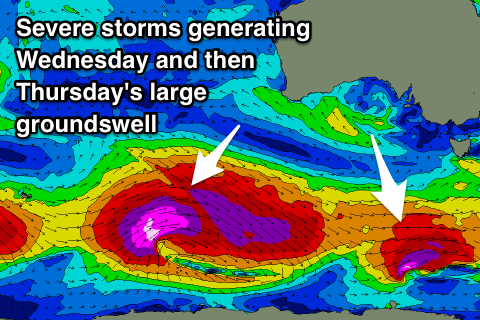
We've currently got a series of severe storms spread out along the polar shelf extending from the south-western of Tassie to the southern Indian Ocean.
The system linked to Wednesday's swell is producing a fetch of severe-gale W'ly winds on top an active sea state in our southern swell window, with a long-period S/SW groundswell due to arrive through the morning.
Thursday's larger groundswell is being generated by the strongest of the polar storms with a significant and broad pre-frontal fetch of severe-gale W/NW winds setting up an active sea state for post-frontal severe-gale to storm-force W/SW winds to move over, traversing east under the country and then under Tasmania.
A large, powerful and long-period SW will be generated, filling in overnight Wednesday and peaking Thursday to 6-8ft across the Middleton stretch and deep water reefs, larger at Waits and Parsons. The Mid Coast looks to remain tiny with a bit of south in the direction, with tiny 1ft+ waves due.
Winds will remain poor across the South Coast Thursday and fresh from the S/SE, E-E/SE Friday as the swell starts easing.
The winds from the eastern quadrant will be a result of a strong slow moving high sliding in from the west being squeezed by a surface low off the southern NSW coast, which will persist through the weekend.
We're likely to see winds dip NE on Saturday as a small trough approaches from the west, reverting back to the SE on Sunday as another high slides in from the south-west.
Swell wise, the easing trend from Thursday will be softened by reinforcing S/SW groundswell pulses from trailing fetches of W'ly gales along the polar shelf in the wake of the largest storm.
The Mid Coast won't see any love from these swells, while conditions will remain average down South.
Longer term winds look to persistent from the eastern quadrant until at least late week, but more on this Wednesday.


Comments
Cleanup sets in the Bay.
you gotta be fit to surf this section of coast at this size fun but