Strong swells incoming for the period with a couple of pumping days in the mix
South Australian Forecast by Craig Brokensha (issued Friday 28th September)
Best Days: Mid Coast beginners tomorrow, South Coast Sunday, Monday and Wednesday morning
Recap
Not too much in the way of surf across both coasts the last two days with tiny to flat conditions, a touch bigger today but only for the desperate.
Today’s Forecaster Notes are brought to you by Rip Curl
This weekend and next week (Sep 29 – Oct 5)
A building mid-period W/SW swell later today is expected to peak tomorrow across both coasts, generated by a relatively weak but broad cold front that's pushed in from the west the past couple of days.
The Mid Coast should see 1-1.5ft sets on the favourable parts of the tide with 3ft waves off Middleton, with the odd sneaky bigger one likely at times.
Keep in mind that Wave Watch is incorrectly combining a very inconsistent and small long-period swell with this new mid-period energy and over-forecasting the size on the weekend.
 Winds tomorrow are still looking onshore and out of the SW-S/SW creating average conditions, while the Mid Coast looks clean and good for beginners with a morning S/SE breeze.
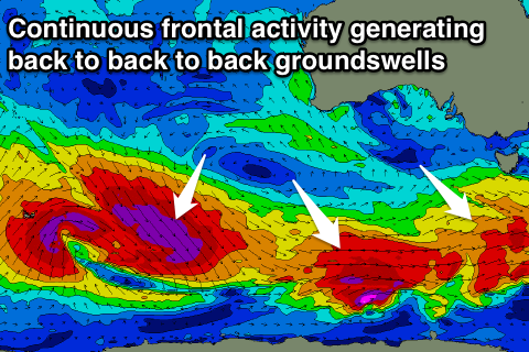
Our stronger pulses of SW groundswell from Sunday with better winds is still on track, with these swells generated by back to back pre-frontal fetches of W/NW gales moving in from the south-east Indian Ocean and under the country today through the weekend.
An initial front should produce a good kick in size to 3-4ft across Middleton through Sunday afternoon with the swell not ideal for the Mid, with inconsistent 1ft+ sets, while a secondary front moving in on top the active sea state ahead of it will generate the strongest pulse of swell for Monday.
Good and fairly consistent sets to 4ft are due off Middleton Monday, continuing around 1ft+ on the Mid Coast, with a drop in size expected from Tuesday.
Winds will swing back offshore on Sunday and out of the NE-N/NE through the morning, variable into the early afternoon ahead of sea breezes. This will see improving conditions with the building and strengthening swell. Monday looks to play out similar though with a touch more stable N/NE offshore, tending variable ahead of mid-afternoon sea breezes.
Winds may go a little funky on Tuesday as a mid-latitude low approaching from the west brings more E'ly breezes, back to the NW to SW Wednesday as the low pushes east across us.
Longer term back to back long-period pulses of S/SW-SW groundswell are due Wednesday and Thursday afternoon next week as an initial polar fetch of severe-gale W’ly winds paves the wave for a much more significant polar low, projecting severe-gale W/NW and then W/SW winds through our south-western swell window.
These swells look to arrive with less than ideal winds and conditions, but more on this Monday. Have a great weekend!


Comments
Got in nice and early today Craig. Going away for the long weekend and wanted to beat the traffic?
Snow must be calling hey Craig ; )
Haha you all know me too well. Not snow this weekend, up the coast and just getting as much done over the high tide. It's now on the drop so time for a paddle, back later..
So Sunday morning down south will be more like 3ft?
Yeah off Middleton if not for the odd bigger one.