Poor end to the week, great from Sunday
South Australian Forecast by Craig Brokensha (issued Wednesday 26th September)
Best Days: Beginners Mid Coast Saturday, Sunday onwards across the South Coast
Recap
Terrible conditions across the South Coast yesterday with a junky mix of windswell and easing groundswell with sloppy conditions, tiny to flat on the Mid Coast.
This morning the South Coast was cleaner and has since improved considerably with a fresh offshore wind, but the swell has faded and swell magnets are the only option for a wave.
Today’s Forecaster Notes are brought to you by Rip Curl
This week and weekend (Sep 27 – 30)
The end of the week isn't looking too special at all with the swell bottoming our tomorrow down South along with average onshore W/SW winds (possibly W'ly early around Victor).
The Mid Coast will be onshore with a tiny windswell that may push to 0.5-1ft if we're lucky.
A broad but relatively weak front will develop south of WA today and direct a fetch of strong to near-gale-force W//SW winds through our south-western swell window tomorrow, before slipping across Tassie on Friday.
The strength of this front has been upgraded slightly and with this we should see an earlier arrival time Friday afternoon and a touch more size when it peaks Saturday.
 Middleton is expected to build slowly through Friday but with onshore SW winds, reaching 2-3ft by dark, while the Mid Coast looks to reach 1-1.5ft with a mix of windswell and stronger mid-period energy.
Saturday should reveal more size and power to the 3ft+ range across the Middleton stretch while the Mid Coast looks to persist at 1-1.5ft on the favourable parts of the tide.
Our models are incorrectly combining a very inconsistent and small long-period swell with this new mid-period energy and over-forecasting the size on the weekend.
Unfortunately winds will remain average and linger from the S/SW into Saturday, cleaner on the Mid with an early S/SE breeze.
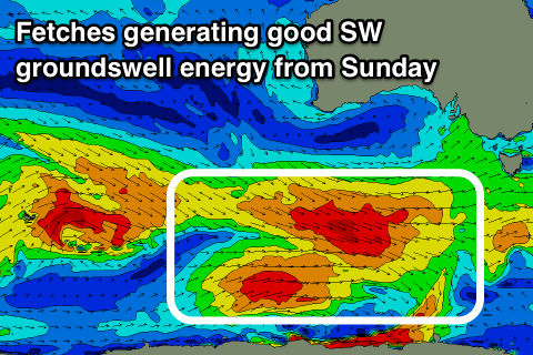
We've got better conditions and stronger swells from Sunday though with an elongated fetch of W/NW gales pushing in from the Heard Island region over the coming days, broadening through tomorrow south of WA and then pushing a bit further north towards us into Friday.
This should generate a moderate to large SW groundswell that's expected to build Sunday afternoon, peaking overnight with a reinforcing pulse for Monday.
Middleton should build to 3-4ft later Sunday and hold around the 4ft range on Monday, with the Mid Coast seeing persistent sets in the 1ft+ range.
Winds will improve on Sunday and swing offshore from the N/NE creating great conditions down South most of the day, only tending variable into the afternoon, with similar N/NE winds on Monday.
A slow moving mid-latitude low looks to keep favourable N/NE winds persisting across the coast on Tuesday as the swell eases, swinging onshore mid-week as it pushes east.
Longer term we may see a very strong polar low developing along the polar shelf early next week, generating a moderate to large S/SW groundswell for later in the week, but more on this Friday.

