Tricky week, more activity from Sunday
South Australian Forecast by Craig Brokensha (issued Friday 24th September)
Best Days: Keen surfers South Coast tomorrow morning and swell magnets Wednesday, Sunday onwards
Recap
Pumping waves across the South Coast Saturday morning with Friday's late spike in S/SW swell hanging in at a good 3-4ft off Middleton, easing through the day, onshore and average into Sunday.
The Mid Coast was tiny Saturday, while a new pulse of SW swell provided more size than expected yesterday with good clean 1-2ft sets which backed off to a tiny 1ft+ or so this morning.
The South Coast continued to provide plenty of size this morning but conditions remain less than ideal with moderate to fresh E/SE winds.
Today’s Forecaster Notes are brought to you by Rip Curl
This week and weekend (Sep 25 – 30)
Conditions will remain less than perfect on the South Coast tomorrow as our current SW swell eases, but Wednesday is looking super fun still at swell magnets with a new S/SW groundswell and offshore winds.
We should see easing surf from the 3ft range off Middleton tomorrow, tiny on the Mid Coast with a morning E/NE breeze, possibly tending NE at times before SE sea breezes kick in.
Come Wednesday offshore N/NE winds are due to swing NW into the afternoon along with a fun new S/SW groundswell produced by a polar frontal system skirting the polar shelf the last day or two.
While not ideally aligned in our swell window we should see the swell fill in through the morning, offering 2ft+ waves off Middleton, a bit bigger at magnets and more to 3ft.
 The Mid Coast will become effectively flat with the southerly and small nature of the swell.
We're looking at tiny waves Thursday with W/SW breezes, (W/NW around Victor for a period) ahead of some new mid-period W/SW swell building Friday and peaking Saturday.
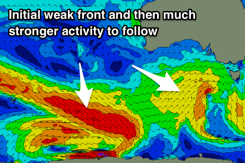
This will be generated by a broad but weak front pushing in from the west mid-late week.
With wind strengths failing to reach gale-force we're not expected to see any major size, and the models are incorrectly combining a very long-period and long-range groundswell from south-east of South Africa with the mid-period energy and over-forecasting the size.
Middleton should see 3ft sets, with the Mid Coast coming in at 1ft+ though with onshore SW winds, tending more W/SW through the day.
A high quickly moving in from the west on Sunday should see winds swing back offshore from the NE along with some better and stronger SW groundswell energy as a broad and elongated polar frontal progression fires up through the Southern Ocean.
Fetches of W/NW-W/SW gales should produce moderate sized pulses of SW groundswell from Sunday with a possible larger swell on the cards for later next week, but more on this Wednesday.

