Great run for the South Coast, with a window for the Mid Coast
South Australian Forecast by Craig Brokensha (issued Wednesday 12th September)
Best Days: South Coast every day besides Saturday, Mid Coast early Thursday
Recap
After Monday's pumping surf, yesterday was always going to be a bit of a let down. Onshore winds kicked in across the Mid Coast after a fresh morning N'ly while the South Coast was super fun with sets dropping back from 3ft off Middleton, bumpier into the afternoon.
Today a new W/SW swell has filled in with easy 3ft sets on the Mid Coast though with average conditions and workable waves in protected spots down South, though winds have since shifted more W. We should see Middleton and the Mid Coast hitting the fairly consistent 4ft range with the peak of swell later this afternoon/evening.
Today’s Forecaster Notes are brought to you by Rip Curl
This week and weekend (Sep 11 – 16)
The strong mid-latitude storm linked to today's large kick building W/SW groundswell has since drifted south-east and across Victoria and Tasmania, and with this we'll see the swell peaking this evening and easing back through tomorrow.
Winds will be great for the South Coast with a N/NW-NW offshore, early and workable from the N/NE on the Mid Coast with easing sets from the 2-3ft range, 3ft+ off Middleton.
The easing trend only looks temporary though, with some new W/SW groundswell due to arrive later in the day, peaking Friday morning.
This has been generated the last couple days by a broad and elongated fetch of W'ly gales moving in from the south-east Indian Ocean. The fetch has now taken a W/NW angle, away from our swell window, with the swell due to arrive later tomorrow and keep Middleton up around 3ft+ Friday morning with 2ft+ waves on the Mid Coast.
Conditions will be good again most of Friday with a fresh N/NW'ly, swinging more W/NW through the afternoon ahead of a stronger W/SW change later in the day.
 Yet another swell is due to arrive later in the day, this being a mix of long-period W/SW and SW groundswell, peaking Saturday morning, but then being overridden by an even bigger W/SW swell.
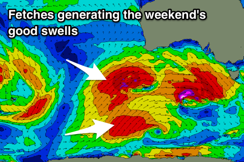
The mix of W/SW and SW swells are being generated by a better aligned and slightly stronger fetch of gale to near-severe-gale W/SW winds stalling south-southwest of WA along with a secondary W/SW fetch projecting under WA tomorrow.
Middleton should see 4-5ft sets Saturday morning from this swell source, with 3ft waves on the Mid Coast, but of a vigorous front pushing in through the evening which will bring with it a larger W/SW swell on top.
A fetch of severe-gale W/SW winds will be originally projected towards us, weakening while passing under WA and through the Bight and then across us Friday evening.
The Mid Coast will see sets to 3-4ft, with Middleton likely to be a similar size to the groundswell due through the morning, 4-5ft.
Winds won't be great and fresh to strong from the W/SW, easing and tending more SW through the day on the Mid Coast.
Sunday should be much better as an approaching front swings winds from the W/NW to NW through the afternoon as the mix of swells ease, smaller Monday
We're only looking at a temporary low point in swell, with a deep and powerful low forming in the southern Indian Ocean forecast to generate a slow moving fetch of severe-gale to storm-force W/SW winds though our swell window from Friday through the weekend, weakening while moving under the country early next week.
A moderate to large W/SW groundswell is currently expected, filling in Tuesday afternoon and easing Wednesday with W'ly winds, but more on this Friday.

