Lots of wind and swell to come this period
South Australian Forecast by Craig Brokensha (issued Monday 10th September)
Best Days: South Coast tomorrow morning, protected spots down South Wednesday, Thursday and Friday morning South Coast, South Coast Sunday
Recap
Super fun waves across both coasts on Saturday with a drop in W/SW groundswell from 2ft on the Mid Coast and 2-3ft off Middleton with favourable winds most of the day.
A new swell filled in yesterday providing another great day of waves down South, with the Mid Coast continuing around a bumpier 2ft.
Today our strong new W/SW groundswell has filled in and provided even better 2-3ft waves on the Mid Coast (below), clean this morning while Middleton is a great though inconsistent 4ft off the Point, bigger down towards Day St and Cliffs.

Today’s Forecaster Notes are brought to you by Rip Curl
This week and weekend (Sep 11 – 16)
Today's swell will ease back through tomorrow and conditions will be best early with a gusty N/NW offshore, swinging W/NW through the afternoon and strengthening as a vigorous mid-latitude front pushes in from the west.
Middleton should ease from 3ft+ on the sets, bigger down towards Goolwa, while the Mid Coast looks bumpy and to 2ft, with an increase in windswell later with the change.
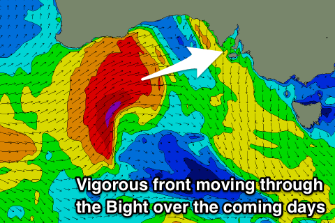
 Now, the mid-latitude front due to push through the Bight over the coming days is currently south-west of WA, with it already producing a great fetch of W/SW gales in our western swell window.
The front will push perfectly through the Mid Coast's swell window this evening and tomorrow while strengthening further with winds reaching severe-gale under WA, passing across us while weakening tomorrow evening and Wednesday morning.
A large acute W'ly groundswell will be generated, filling in on Wednesday and reaching 4ft on the Mid Coast with the South Coast seeing much less size due to the W'ly direction.
Middleton should reach 4ft on the sets as well into the afternoon and winds look to be generally out of the W- likely W/NW at dawn around Victor, W/SW through the morning and maybe back to the W/NW late with an approaching front.
Winds will swing back to the NW-N/NW on Thursday as the swell drops, though later in the day we should see the first in a series of strong new groundswells filling in.
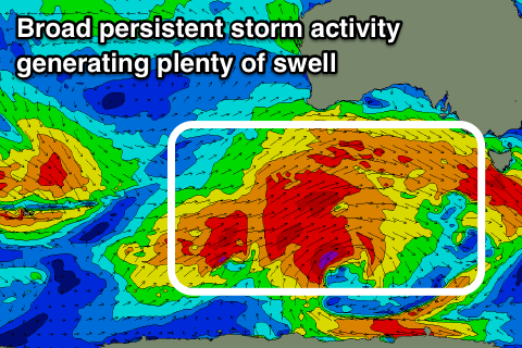
These swells will originate from a broad and elongated frontal progression pushing in from the south-east Indian Ocean through this week, with an initial fetch of W'ly gales tending less favourable from the W/NW on approach Wednesday, generating a new W/SW groundswell for later Thursday and more so Friday to 3ft+ off Middleton, bigger towards Middleton, with the Mid Coast coming in at 2ft+.
A stronger and better aligned SW groundswell should then build through the afternoon generated by a more southerly positioned and better aligned fetch of gale to near-severe-gale W/SW winds on top an active sea state.
 This will see Middleton building later to 4ft+ with 3ft sets developing on the Mid Coast though with a gusty N/NW tending strong W/SW breeze.
The strong change will be linked to a third vigorous polar front piggy-backing over the top of the fronts before it, projecting a fetch of gale to severe-gale W/SW tending SW winds through our western and south-western swell windows.
An even larger groundswell will be created, filling in on Saturday though with poor and strong SW winds, much cleaner and easing on Sunday. We'll have a closer look at this on Wednesday though.


Comments
Swell is pumping this arvo!
The one time I wish I was back home..
High tide goodness..
Was good fun yesterday. Imagine if KI wasn’t in the way, so many different spots would open up, up and down the gulf.
got my vote #blowupki
But guys.. I feel if KI weren't there than we'd see the reefs overpowered? Like once they get to 3-4ft most break wide or closeout, though you could say the whole reef setup would be totally different under this setup.
Always a great one to wonder about.