Good swells for the South Coast with strong winds at times
South Australian Forecast by Craig Brokensha (issued Monday 27th August)
Best Days: Tuesday swell magnets South Coast, Wednesday and Thursday afternoons South Coast, Saturday morning South Coast
Recap
A great weekend of waves across the South Coast with clean conditions and good 3ft sets off Middleton Saturday morning, similar if not a touch stronger Sunday with onshore breezes into the afternoons (poor yesterday with strength).
The Mid Coast saw small to tiny surf all weekend, with some fun sets at magnets through periods.
Today we're back to a tiny clean 0.5-1ft on the Mid Coast with lumpy and bumpy waves down South.
Today’s Forecaster Notes are brought to you by Rip Curl
This week and weekend (Aug 28 – Sep 2)
We should see an improvement in conditions down South tomorrow as a broad and strong mid-latitude low moves in from the west, steering winds more N/NE-NE. This will favour exposed beaches and other spots like Goolwa with an easing mid-period S/SW swell from 2-3ft off Middleton.
Wednesday morning looks average with a low point in swell and stronger N/NE winds as the low nears closer, but into the afternoon a new long-period S/SW groundswell should fill in.
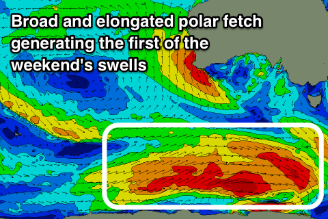
This swell was generated over the weekend by a vigorous polar low forming south-west of WA. A fetch of severe-gale to storm-force W'ly winds were generated in our swell window, with the low currently breaking down south-southwest of WA.
The long-period forerunners are due to arrive through Wednesday morning, with the swell building into the afternoon, reaching 3ft off Middleton by dark, while the Mid Coast isn't due to any size above 0.5-1ft.
Winds are expected to ease but hold from the N/NE into Wednesday afternoon, creating good conditions with the new swell.
We'll see the swell easing through Thursday from a similar 3ft on the sets though under a strong to possibly gale-force N/NE breeze, easing and tending more N/NW into the afternoon. With this outlook the morning will likely be average, with magnets worth a look into the afternoon.
 Friday looks like a lay day with no new swell and NW tending W/SW winds as the mid-latitude low crosses us. It won't have much strength though and with this only a tiny possible W/SW windswell is likely on the Mid Coast.
Moving into the weekend we've got a couple of good S/SW groundswells inbound for the state, but winds look hit and miss.
An initial increase in S/SW groundswell Saturday will be produced by a great pre-frontal fetch of W/NW tending W and then W/SW gales passing far south under the country mid-late week.
We should see a good long-period S/SW groundswell filling in Saturday, building to 4ft off Middleton through the day, but winds will swing from a morning W/NW breeze around to the S/SW through the day.
Into Sunday a larger S/SW groundswell should be seen, generated by a secondary vigorous and broad polar front forming south of WA and projecting north-east up towards Tassie through Friday and Saturday.
This swell looks to come more in the 5ft range but with SE winds, possibly tending E'ly for a period through the morning. This isn't ideal and each swell won't be favourable for the Mid Coast with tiny 0.5-1ft surf due. Cleaner conditions should be seen into early next week as the swell eases, but more on this Wednesday.

