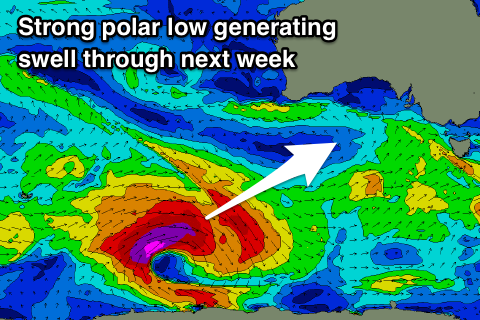
Fun swells with winds from the eastern quadrant
South Australian Forecast by Craig Brokensha (issued Friday 24th August)
Best Days: Saturday and Sunday mornings South Coast, South Coast magnets Tuesday morning, later Wednesday and Thursday morning
Recap
Tiny clean waves on the Mid Coast yesterday, ideal for beginners, while the South Coast was fun though a little lumpy through the morning, cleaner through the day as some new long-range W/SW groundswell filled in later.
This morning this groundswell has provided good inconsistent 1ft to occasionally 2ft sets on the Mid Coast with 3ft'ers off Middleton and more size down the beach with favourable winds which are still offshore from the NE this afternoon.
Today’s Forecaster Notes are brought to you by Rip Curl
This weekend and next week (Aug 25 - 31)
Today's inconsistent W/SW groundswell should ease off through tomorrow, only to be replaced by some new inconsistent SW groundswell, generated earlier this week by a good broad fetch of pre-frontal W/NW gales south-west of WA.
We should see Middleton hanging in at an infrequent 3ft on the sets, while the shift in swell direction will cause a drop in size back to 1ft+ on the Mid Coast.
Sunday should see similar sized sets waves, with some new mid-period S/SW swell due to build through Monday.
But firstly coming back to the expected conditions and tomorrow should be clean if not a little lumpy down South with variable winds out of the E/NE ahead of relatively weak sea breezes.
 Sunday also looks clean with a morning W/NW offshore, but a polar front approaching from the south will bring a SW tending S/SW change late morning.
This change will be linked to Monday's new mid-period S/SW swell, with a weak polar frontal system that's south-west of WA today due to project a broad fetch of strong W/SW tending SW winds through our southern swell window tomorrow and Sunday.
A continuation of weaker 3ft waves are expected off Middleton and more so into the afternoon, tiny on the Mid Coast.
Winds are looking a bit better for Monday morning and not straight onshore, but still average with moderate to fresh E/SE breezes persisting all the day.
Tuesday will be cleaner as the mid-period S/SW swell eases from 2-3ft under a NE offshore, favouring swell magnets.
Looking longer term and a low point in swell is expected on Wednesday with gusty NE winds, stronger out of the N'th on Thursday as a deep and broad mid-latitude low moves in from the west. A new long-period SW groundswell is due later Wednesday and Thursday morning produced by a strong but tight polar low south-west of WA, but more on this Monday. Have a great weekend!

