Another strong west swell, cleanest on the South Coast
South Australian Forecast by Craig Brokensha (issued Monday 13th August)
Best Days: South Coast tomorrow, Thursday in protected spots, Friday
Recap
Fun clean waves in protected spots down south over the weekend and this morning, fairly raw yesterday and a bit more organised and stronger in energy this morning.
The Mid Coast was a poor and choppy 2-3ft Saturday, dropping back a bit into yesterday and remaining small today with onshore winds.
Today’s Forecaster Notes are brought to you by Rip Curl
This week and weekend (Aug 14 - 19)
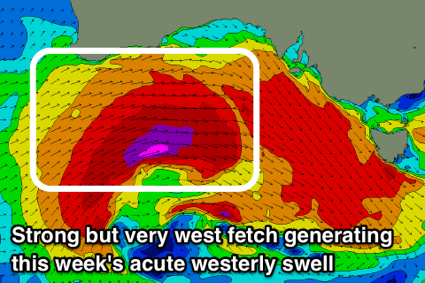
We should see the surf hanging in around a similar size across both coasts through tomorrow as a reinforcing W/SW swell fills in, generated by a good but poorly aligned fetch of strong to gale-force W/NW winds in from under WA.
The Middleton stretch should persist at 2-3ft with great though strengthening N/NW winds, with 1-1.5ft waves on the Mid Coast and N/NE tending N/NW winds.
A low point in swell is due early Wednesday, but we'll see some new W/SW swell energy quickly take its place, generated by a strong mid-latitude low pushing in from the west.
This low is expected to form this evening south-west of WA and project a fetch of severe-gale to near storm-force W/SW winds under WA and through the Bight tomorrow, weakening slowly while pushing across us on Wednesday.
Middleton looks to start from a small 2ft base, building in size and power through the day to 3ft+ by dark under a fresh and gusty W/NW tending W/SW breeze.
 The Mid Coast looks choppy and 1-2ft, building more towards a consistent 2ft through the day.
A peak in groundswell is due Thursday morning, quickly easing with sets to 4ft along the Middleton stretch (bigger off Goolwa) and easing 2-3ft sets on the Mid Coast with a persistent and moderate to fresh W/NW breeze.
Friday will be cleaner across more exposed spots down South with a NW offshore and easing sets from 3ft off Middleton.
The start of the weekend it's looking too flash with smaller background levels of W/SW and SW swell along with deteriorating winds as a polar front clips us, bringing developing SW-S/SW winds.
Sunday will then be average with lingering S/SE onshore winds and a new mid-period S/SW swell from the front proper, only coming in around 3ft or so.
Longer term there's nothing too major on the cards until late week across our region as the mid-latitude frontal activity settles down for a short-period. We'll have a closer look at this Wednesday though.

