Great westerly groundswell mid-week
South Australian Forecast by Craig Brokensha (issued Monday 30th July)
Best Days: South Coast tomorrow afternoon, both coasts Wednesday (Mid Coast until early afternoon), South Coast Thursday morning if not too windy, Saturday and Sunday South Coast
Recap
Fun waves right across the South Coast on Saturday with a drop in swell from Friday leaving smaller but clean conditions from Goolwa to Parsons. The Mid Coast dropped back to a tiny and bumpy 0.5-1ft.
A stormy jump in W/SW swell was seen across the Mid Coast on Sunday to 2-3ft with poor conditions, while the South Coast kicked to 3ft, but with less than ideal winds.
The swell continued to kick through the afternoon and this morning we've got a mix of swells (including a long-range and inconsistent long-period W/SW groundswell) providing clean 3-4ft surf off Middleton. The Mid Coast was hanging in at 2-3ft, but with poor onshore winds. The swell is now on the ease though and we'll see conditions remain good though windy down South with a persistent fresh to strong N/NW offshore.
Today’s Forecaster Notes are brought to you by Rip Curl
This week and weekend (Jul 31 – Aug 5)
Want to receive an email when these Forecaster Notes are updated? Then log in here and update your preferences.
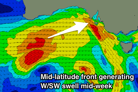
Today's spike in swell was generated by an intense mid-latitude low pushing across us yesterday, and this swell along with the long-period and inconsistent W/SW groundswell will ease this afternoon, smaller into tomorrow morning.
An uptick in new mid-period W/SW swell is expected through the day (from dawn across the Mid Coast) followed by a better groundswell on Wednesday.
 These swells have been generated by a strong mid-latitude frontal system developing in the Indian Ocean late last week, pushing east over the weekend and producing a fetch of gale-force W/SW winds south-west of WA and through the Bight last night and today.
This frontal system is moving in from the west and will cross us this evening, bringing fresh and gusty W/NW winds tomorrow.
The Mid Coast looks to come in at a messy and choppy 2ft, kicking a little bigger later in the day ahead of a peak Wednesday to a good 3ft on the sets and fairly consistent.
Middleton looks smaller tomorrow morning and back to 2ft to maybe 3ft, building into the afternoon to 3ft+, but Wednesday will see the most power and size with sets to 4ft.
Conditions will be great as well Wednesday with an approaching mid-latitude frontal progression swinging a possible dawn W/NW'ly quickly around to the NW and then fresh N/NW into the afternoon down South.
The Mid Coast will improve before deteriorating as winds tend variable and then kick up from the N/NW. The mid-late morning and early afternoon look best.
The approaching mid-latitude frontal progression will sit too far north to generate any swell when it crosses us later week, with an easing trend due across both coasts on Thursday along with a blustery and strong N'ly tending N/NW breeze. This will likely kick up some N/NW windswell later in the day on the Mid Coast to 2ft+.
From Friday and more so the weekend we'll see a slow increase in W/SW groundswell energy initially generated by storms in our far swell window, moving closer later week.
A small weak 1-2ft wave is likely on the Mid Coast Friday from an overnight change, while Middleton only looks to come in at a small 2ft under W'ly winds.
A slightly stronger W/SW swell is due Saturday from a fetch of weakening W/SW winds pushing up and over WA this Wednesday/Thursday but the best swells are due into Sunday/Monday.
A good fetch of pre-frontal W/NW gales will swing in from the Indian Ocean through our western swell window, followed by a stronger post-frontal fetch of severe-gale W/SW winds.
Two seperate W/SW groundswell pulses are due, the first for Sunday and second stronger pulse for Monday.
At this stage we're looking at increasing consistency of sets around 2ft across the Mid Coast from Saturday into Sunday, peaking on Monday to a good 2-3ft. The South Coast will be generally small with the west in the swells, best Monday and to 4ft or so.
Winds on the weekend will strengthen from the N/NW Saturday ease temporarily Sunday ahead of an approaching change and then from the W on Monday. The models are still shifting around slightly regarding the incoming frontal activity, so check back here Wednesday for a more accurate idea on the weekend and early next week's outlook.

