West, west and more west
South Australian Forecast by Craig Brokensha (issued Friday 27th July)
Best Days: Saturday South Coast, Monday morning South Coast, Tuesday afternoon South Coast, Wednesday South Coast, Thursday both coasts
Recap
Pumping waves across the South Coast yesterday with good straight clean 3-4ft waves all day off Middleton, while the Mid Coast saw good 2ft to occasionally 3ft waves with generally light winds most of the day.
This morning the swell was on the ease but still good across the South Coast, dropping from 3ft on the sets of Middleton with tiny bumpier 1-1.5ft waves on the Mid Coast.
Today’s Forecaster Notes are brought to you by Rip Curl
This week and weekend (Jul 28 – Aug 3)
Want to receive an email when these Forecaster Notes are updated? Then log in here and update your preferences.
Tomorrow morning will be fun at swell magnets on the South Coast as today's S/SW swell eases back from 2ft off Middleton with bigger waves at magnets under a light N/NW breeze, increasing and swinging more W/NW through the afternoon.
The Mid Coast will be clean early but struggling to reach 1ft.
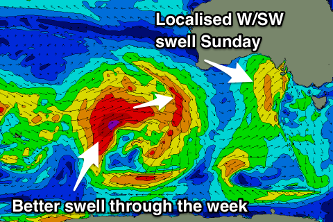
Into Sunday a mix of mid-period W/SW swell, windswell and building long-range W/SW groundswell are due.
The mid-period and W/SW windswell are being generated by a front pushing in from the south-west of WA, through the Bight tomorrow and across us into the evening and Sunday morning.
 We'll see weak levels of W/SW swell to 2ft+ Sunday morning, increasing more to 2-3ft through the afternoon, while the South Coast looks fairly average with weak 2-3ft windswell waves down across the Middleton stretch, increasing a little more into the afternoon.
Strong W/SW winds will create poor conditions with the likelihood of an early W/NW'ly around Victor now very low.
Also in the mix will be our long-range W/SW groundswell, generated by a very broad and expansive polar low that formed in the southern Indian Ocean this week.
This low has generated another XL groundswell for Indonesia and XXL W/SW groundswell for WA, but for us we're expected to see moderate sized levels of swell, larger off the West Coast.
This swell is due to fill in Sunday afternoon, peaking overnight/early Monday but to a size under the local swell generated through Sunday, and possibly a touch over it on the South Coast Monday morning.
We're looking at inconsistent 3ft to possibly 4ft sets off Middleton Monday morning, easing through the day, with 2ft+ waves on the Mid Coast. Another approaching front will swing winds around to the N/NW, strengthening through the day and likely kicking up 2-3ft of NW windswell by dark.
This strengthening north-wester will be linked to a stronger mid-latitude frontal progression moving in from the west, bringing with it another moderate to large W/SW groundswell mid-week.
The mid-latitude progression has already started its life in the southern Indian Ocean with a fetch of W/SW gales pushing through our far western swell window.
The progression will continue east and push under WA's South Coast Sunday evening, and through the bight early Saturday and then across us Monday evening.
An increase in mid-period W/SW swell is due Tuesday ahead of the groundswell proper Wednesday, with the Mid Coast coming in at 2ft+ on the former and 2-3ft Wednesday.
Middleton looks smallish Tuesday morning with an afternoon kick in size, much better Wednesday with sets to 4ft, helped along by a small embedded low pushing under the region Tuesday evening.
Winds will be favourable for the South Coast and out of the W/NW on Tuesday, with better W/NW tending NW winds on Wednesday.
Into the end of the week the mix of swells will ease under a strong N/NE breeze Thursday and W/SW change Friday as another significant mid-latitude frontal system pushes across us, but we'll discuss this more on Monday. Have a great weekend!

