Easing swell with great conditions
South Australian Forecast by Craig Brokensha (issued Wednesday 25th July)
Best Days: South Coast Thursday, Friday and magnets Saturday morning, Mid Coast Thursday, South Coast Monday
Recap
Good conditions at dawn yesterday across the South Coast with a new lift in swell, but winds quickly strengthened and created tricky conditions with the inconsistent swell. The swell slowly build through the day with OK waves in protected spots late, much better today with strong but inconsistent 4-5ft sets off Middleton early this morning, easing through the day.
The Mid Coast was solid but poor with the strong N tending NW winds yesterday, much better today with cleaner conditions under a weaker NW breeze and sets in the 3ft range.
Today’s Forecaster Notes are brought to you by Rip Curl
This week and weekend (Jul 26 - 29)
Want to receive an email when these Forecaster Notes are updated? Then log in here and update your preferences.
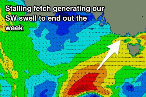
Our current mix of long-period and mid-period W/SW swells are due to ease through tomorrow, but a fun reinforcing S/SW swell should be seen into the afternoon and Friday morning across the South Coast, produced by a stalling fetch of W/SW gales through our southern swell window last night and this morning.
Middleton should ease back from 3-4ft tomorrow morning, though holding 3ft+ into the afternoon with the new S/SW swell, easing back from 3ft Friday morning.
The Mid Coast will ease more of a drop in size, easing back from 2ft tomorrow, tiny Friday.
 Winds will be great for the South Coast and good for the Mid tomorrow with a N/NE tending N/NW breeze (likely variable across the Mid into the afternoon).
Friday will then see N/NE winds most of the day, possibly giving into sea breezes through the afternoon, but most likely remaining variable.
The swell will continue to ease on Saturday and magnets will be best early (fading from 2ft at Middleton) on the South Coast with a light N/NW offshore, increasing through the day and tending more W/NW.
This swing in winds will be associated with a strengthening front come mid-latitude low moving in from the west, projecting a fetch of strong to gale-force W/SW winds through the Bight and new W/SW swell for Sunday.
As the low forms while passing across the South Coast we'll see stronger SW gales generated briefly in its swell window, generating an additional SW tending S/SW swell for Sunday afternoon and Monday.
The Mid Coast looks as if it will come in at a messy 3ft with strong but easing W/SW winds, while Middleton looks to come in at weak mid-period 3-4ft with similar winds, though likely out of the W/NW early.
Monday looks better with the reinforcing S/SW swell and offshore N/NW winds as another front approaches from the west. Size wise, Middleton looks to persist at 3-4ft, easing into Tuesday. The Mid Coast looks to drop back to 2ft+.
Also in the mix later Sunday and Monday morning will be a strong long-period and inconsistent W/SW groundswell, generated currently in the southern Indian Ocean by a very broad and significant polar low.
The size expected off this low will be under what will be generated by the localised low moving through our region and very inconsistent, but should be mentioned in any case.
Longer term another strong mid-latitude front pushing in from the west Sunday and Monday will bring more swell mid-late week, but we'll have a closer look at this Friday.

