Windy sizey swells continue, more from the south on the weekend
South Australian Forecast by Craig Brokensha (issued Wednesday 13th June)
Best Days: Protected spots down South tomorrow morning and early Friday morning, Mid Coast Monday, South Coast Tuesday
Recap
Solid stormy waves across the Mid Coast yesterday with a mix of W'ly groundswell and windswell while the South Coast was average with W'ly winds and a small W'ly swell.
Dawn this morning conditions were much better with clean fun 3ft sets off Middleton, but the swell has since eased and winds gone more west creating average conditions. The Mid Coast was back to a messy 2ft+.
Today’s Forecaster Notes are brought to you by Rip Curl
This week and weekend (Jun 14 - 17)
Want to receive an email when these Forecaster Notes are updated? Then log in here and update your preferences.
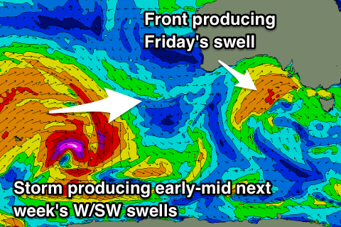
Currently a weakening mid-latitude front is pushing into us and with this we might see a late increase in weak W/SW windswell, but some better mid-period and groundswell energy are due into tomorrow, produced by the earlier stages of the storm.
Since the weekend this storm has been aiming a fetch of initial severe-gale to storm-force W/SW winds from the Heard Island region, up towards WA and then through the Bight while weakening.
We should see good 2-3ft waves on the Mid Coast with 3ft+ sets off Middleton, easing back through the middle of the day, while another strong mid-latitude front pushing into us through the afternoon will start to kick the surf up again before dark.
Winds will strengthen from the W/NW-NW through tomorrow morning favouring protected spots, shifting back to the W through the afternoon, if not W/SW late in the day.
Come Friday W/SW tending SW groundswell from the front will be seen from the mid-latitude front pushing into us, keeping the Mid Coast up at 3ft, while Middleton will see larger 4-5ft waves.
 Winds will be strong from the W/SW all day, but the Victor region is likely to see an early W'ly, favouring protected breaks again.
Into the weekend, moderate to large levels of S/SW tending S swell are expected across the South Coast as the mid-latitude front pushing into us Thursday evening spawns a low pressure centre, with the low stalling just south of Tassie Friday and Saturday, projecting persistent strong to gale-force S/SW winds in our southern swell window.
We're looking at 4-5ft+ waves on Saturday, possibly more 4-6ft Sunday morning before the swell starts to ease later in the day and more so Monday as the low weakens and pushes east.
Unfortunately with the slow moving nature of the low we'll see poor and fresh to strong SW winds Saturday, fresh and SW tending S/SW on Sunday and S/SE on Monday.
The Mid Coast will ease through the weekend with the southerly swell becoming dominant, down from 2ft+ on Saturday but onshore, down from 1ft to maybe 2ft Sunday and still messy.
Into early next week some new long-range and inconsistent W/SW groundswell is due, produced by a broad and slow moving storm in the southern Indian Ocean over the coming days.
An initial swell for later Sunday and Monday may provided very inconsistent 1-2ft sets on the favourable parts of the tide on the Mid Coast, with a secondary broader storm providing similar sized sets later in the day and Tuesday. The South Coast is likely to see infrequent 2-3ft sets off Middleton, with N'ly winds into Tuesday, but more on this Friday.

