Lots of windy westerly swell
South Australian Forecast by Craig Brokensha (issued Monday 11th June)
Best Days: Early tomorrow down South, Thursday down South, early Friday down South and Sunday morning down South
Recap
Great waves across both coasts Saturday with a new W/SW groundswell to a clean 2-3ft on the Mid Coast and 3-4ft off Middleton with pumping solid surf at Waits for the Hurley Winter Classic which was taken out by Tim Macdonald.
Sunday was back to 1-1.5ft on the Mid Coast with the swell dropping right back, while the South Coast was fun and best at the magnets.
This morning we're back to the tiny stuff down South with tiny lumpy waves on the Mid ahead of a building NW windswell this afternoon.
Today’s Forecaster Notes are brought to you by Rip Curl
This week and weekend (Jun 12 - 17)
Want to receive an email when these Forecaster Notes are updated? Then log in here and update your preferences.
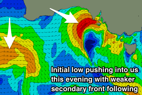
Today's strengthening NW tending W/NW wind is linked to an intense mid-latitude low that's currently pushing in from the west.
 We're seeing a tight fetch of strong to gale-force W'ly winds aimed directly through the Mid Coast's western swell window, but not ideally at all for the South Coast until the system pushes east of Kangaroo Island early tomorrow morning.
An inconsistent W'ly groundswell generated over the weekend should provide a bit more size across the South Coast, but again it wasn't positioned ideally through its swell window at all.
But coming back to the W'ly swell due on the Mid Coast tomorrow and we should see stormy 3ft+ waves with strong but easing W/SW winds.
The South Coast looks to come in at an inconsistent 2-3ft off Middleton, small to tiny around Victor with the west direction and bigger at Waits and Parsons, but only clean in protected spots with that W/SW breeze (possibly W'ly early).
A temporary low point in swell early Wednesday but another weakening mid-latitude front that will develop south-west of WA today and project east through the Bight tomorrow, will bring a building W/SW windswell as it moves across us Wednesday, with groundswell to follow Thursday morning.
The Mid looks to hang around 2ft all day, if not for the odd bigger one on the favourable parts of the tide, but with gusty W/SW winds.
The South Coast looks weak and around 2ft+ through the morning off Middleton, building more to 3ft into the afternoon as winds shift W/SW.
 Thursday morning should reveal more size and power with 3ft+ sets off Middleton, easing into the afternoon and 2-3ft sets on the Mid Coast.
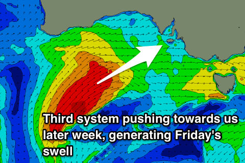
Winds will veer more NW and then strengthen from the W/NW through the day with another stronger mid-latitude storm racing in quickly from the south-west.
This front will project stronger gale-force W/SW winds right up and into us through Wednesday afternoon and evening, into us Thursday afternoon before spawning into a low and continuing to aim strong SW winds through our southern swell window Friday.
This should create a larger W/SW tending SW swell for Friday and Saturday, keeping 2-3ft waves hitting the Mid Coast, while Middleton is expected to offer larger 4-5ft+ waves on Friday, easing back from a similar size Saturday morning.
Unfortunately winds will be fresh to strong from the W/NW tending W/SW on Friday, with SW breezes Saturday hopefully back to the W/NW Sunday morning.
We'll review this as the models diverge slightly on the movement on the low once it pushes east of us on Friday.

