Good W/SW swell Wednesday, with a large S/SW groundswell Friday morning
South Australian Forecast by Craig Brokensha (issued Monday 14th May)
Best Days: Mid Coast Wednesday, South Coast Thursday morning and Friday morning
Recap
Average conditions across the South Coast all weekend, solid Saturday and a bit smaller Sunday, while this morning the surf is back to the 2ft range off Middleton but clean and peaky with a light offshore wind. The Mid Coast was average Saturday with great beginners waves yesterday and this morning.
Today’s Forecaster Notes are brought to you by Rip Curl
This week and weekend (May 15 – 20)
These notes will be brief as Ben's on holidays.
Tomorrow will be a lay day as the swell continues to ease and a strong high moves in from the west, bringing poor S/SE winds. This will kick up a funky S/SE windswell during the day across the South Coast as the Mid remains tiny.
Our mix of new W/SW and SW swells for Wednesday are still on track, with the W/SW energy being generated by a strong mid-latitude front pushing through the south-east Indian Ocean over the weekend.
 The swell will be inconsistent but we should see good 2ft sets on the favourable parts of the tide for the Mid Coast, while the South Coast will see a good new S/SW groundswell from a strong polar storm that's currently well south of the Bight.
A fetch of gale to severe-gale W/SW winds should produce a moderate sized S/SW groundswell Wednesday morning to 3ft off Middleton, if not for the odd bigger one before easing through the day. Winds will be great for the Mid Coast and E/SE, while the South Coast isn't looking great with overnight SE winds possibly tending E/SE if we're lucky.
Thursday could be a touch better as winds tend more variable from the SW and the swells from Wednesday ease.
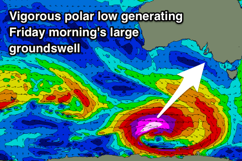
Now, later in the day a strong long-period S/SW groundswell should be seen, generated by an excellent polar low that's due to develop on the polar shelf, south-southwest of WA early tomorrow morning, projecting a fetch of severe-gale to storm-force W/SW winds through our southern swell window right up until passing under Tassie Wednesday evening.
A large long-period S/SW groundswell will be generated for the South Coast, possibly showing on dark Thursday, but peaking overnight and easing Friday from a large 5-6ft on the sets.
A morning W/NW breeze should favour Victor Harbor, while the Mid Coast looks onshore and tiny.
Another strong high is due to move in Friday afternoon, bringing onshore S/SE winds Saturday as the S/SW groundswell eases, smaller Sunday with possibly more variable winds. More on this Wednesday.

